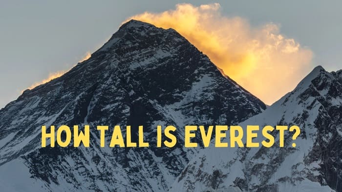
Situated amongst the Great Himalayas in southern Asia, Mount Everest straddles the boarder between Nepal and the Tibet Autonomous Region of China. Standing at a height of 29,032 feet (8,849 meters), Mount Everest proudly claims its title as the tallest mountain in the world.
Mount Everest Height
The height of Mount Everest is 8848 meters or 29,028 feet. However, discrepancies concerning the precise elevation of the summit arose due to variations in snow accumulation, gravitational deviations, and the bending of light.
The Survey of India established the benchmark measurement of 29,028 feet (8,848 meters), during the period from 1952 to 1954. This numerical value gained widespread acceptance. It was embraced by the majority of researchers, cartographic organizations, and publishers until 1999.
Subsequent efforts aimed to reevaluate the mountain’s height. In 1975, a Chinese survey recorded a figure of 29,029.24 feet (8,848.11 meters), while an Italian survey, utilizing satellite surveying techniques, arrived at a measurement of 29,108 feet (8,872 meters) in 1987.
Nonetheless, doubts emerged regarding the methodologies employed. In 1992, another Italian survey harnessed the Global Positioning System (GPS) and laser measurement technology, deriving a value of 29,023 feet (8,846 meters) by deducting 6.5 feet (2 meters) for the accumulation of ice and snow atop the summit. Nevertheless, this methodology, too, faced scrutiny.
Fluctuating Heights of Mount Everest
Regarding the height of Mount Everest, significant variations and debates have shaped the accurate measurement over time. In 1999, an expedition led by the (U.S.) National Geographic Society and other entities employed GPS equipment to conduct meticulous measurements. Their determined height of Mount Everest stood at 29,035 feet (8,850 meters), with a margin of error of 6.5 feet (2 meters). Both the society and experts in the fields of geodesy and cartography widely accepted this conclusion.
In 2005, the Chinese embarked on another expedition, combining ice-penetrating radar and GPS technology. This effort resulted in a “rock height” measurement of 29,017.12 feet (8,844.43 meters), which gained significant media attention. However, this particular measurement found recognition predominantly within China for several subsequent years. A point of contention arose, notably with Nepal, favoring the “snow height” measurement of 29,028 feet.
In April 2010, a bilateral agreement was reached between China and Nepal, acknowledging the validity of both height figures. The landscape shifted again in December 2020 when both nations jointly declared the height of Everest to be 29,031.69 feet (8,848.86 meters).
This new measurement was derived from data acquired during surveys conducted by Nepal in 2019 and China in 2020. Employing cutting-edge technologies such as GPS, BeiDou navigation, and laser theodolites, this measurement garnered acceptance from experts in geodesy and cartography, including the National Geographic Society.
Who Was The First to Measure the Height of Mount Everest?

Radhanath Sikdar calculated the exact height of Mount Everest in 1852.
Back in 1831, George Everest, serving as the Surveyor General of India, found himself on a quest to locate a proficient mathematician well-versed in Spherical Trigonometry. John Tytler, a professor of Mathematics at the Hindu College, recommended his pupil Radhanath to Everest.
Radhanath was tasked with geodetic surveys encompassing the Earth’s geometric shape, orientation in space, and gravitational field. He applied innovative methodologies beyond and established techniques to ensure precise measurements of these parameters.
In 1843, George Everest’s retirement led to Colonel Andrew Scott Waugh taking his role. Subsequently, in 1851, Radhanath’s promotion to Chief Computer prompted his relocation to Calcutta, where he also supervised the Meteorological Department.
Under the directive of Colonel Waugh, Radhanath embarked on measuring the height of Mount Everest. During computations involving northeastern observations, Radhanath determined the altitude of Peak XV (Peak XV was a previous name of Everest) of the as exactly 29,000 feet (8,839 meters). However, Waugh added an arbitrary two feet due to concerns that Sikdar’s measurement might be perceived as rounded rather than precise. Waugh officially announced this outcome in March 1856, establishing it as Mount Everest’s height. This measurement persisted until an Indian survey recalculated the height to be 29,029 feet (8,848 meters) in 1955.
The Story of Mount Everest’s Formation and Composition
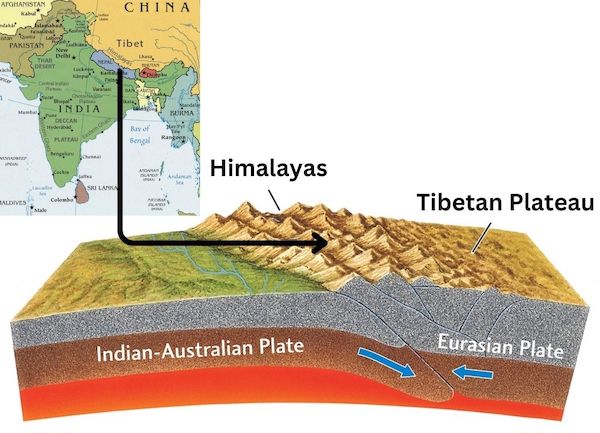
The tectonic forces exerted upon the Himalayan ranges were instrumental in their upward thrust. The Indian-Australian Plate initiated a northward journey from the southern region. It leads to the unfolding of this phenomenon, ultimately experiencing subduction—driving downward—beneath the Eurasian Plate. This intricate dance of the two plates unfolded through a collision that occurred roughly 40 to 50 million years ago. The subsequent outcome was the elevation of the Himalayas.
The genesis of the Himalayas’ ascent dates back approximately 25 to 30 million years, and during the Pleistocene Epoch, spanning from around 2,600,000 to 11,700 years ago, the Great Himalayas began to manifest their present-day configuration. The prominence of Everest and the adjacent peaks is attributed to their role within a vast mountain massif, a pivotal locus or junction of the tectonic activity within the expanse of the Great Himalayas.
Remarkably, insights derived from global positioning instruments positioned on Everest since the late 1990s reveal an ongoing narrative of movement. The mountain’s trajectory continues to carry it a few inches towards the northeast, while simultaneously experiencing a minute annual increase in elevation.
Everest’s composition comprises intricate layers of rock that have undergone folding, forming what are termed nappes. The foundation of the mountain’s lower reaches is constructed from metamorphic schists and gneisses, crowned by igneous granites. As one ascends, sedimentary rocks with a maritime origin become apparent—a vestige of the former floor of the Tethys Sea, which closed following the monumental tectonic collision. An especially notable feature is the Yellow Band, a distinctive limestone formation prominently visible just beneath the summit pyramid.
The Dynamic Evolution of Everest: Tectonic Forces, Growth, and Erosion
Regardless of its exact evolution, the tectonic collision that gave rise to Everest persists to this day. India incrementally inches northward, advancing a few inches annually. Scientists speculate that this ongoing interaction with Eurasia might propel the mountains to even greater heights. In the northwestern stretches of the range, an estimated average elevation uplift of roughly 10 millimeters per year is anticipated, while Everest’s elevation could experience an increase of around a millimeter each year.
The growth is not a consistent progression; rather, it unfolds intermittently due to more forceful shifts in the terrain. The pressure generated by the compression of land as India plunges beneath Eurasia accumulates until it reaches a breaking point. At this juncture, segments of earth can swiftly reposition, triggering ground-shaking earthquakes.
However, it’s important to note that earthquakes don’t invariably result in the mountain’s height increase. The outcome hinges on the precise manner and location of the ground’s movement. Tremors can lead to either marginal growth or contraction in the mountain’s dimensions. This phenomenon may have transpired during the 2015 Nepal earthquake, as indicated by satellite data.
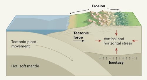
Simultaneously, as the rock strata persistently surge towards the sky, erosion acts as a counterforce to their upward momentum. The wind and water collaborate to erode the surface, sweeping sediment into torrents that cascade down the mountainsides. In the Himalayas, much of this sediment finds its way into the Ganges and Brahmaputra rivers. Upon encountering a gentler slope at the mountains’ base, sand deposits out of the water, contributing to the formation of the world’s largest river delta. This delta underlies the majority of Bangladesh and the Indian state of West Bengal.
While erosion and gravitational forces temper the mountains, the collision of tectonic plates continues unabated. As these geological plates perpetually navigate their interactions, Everest follows their lead.