The question “Where is Nepal located” is a commonly asked question. Many people around the world do not know much about the small Asian country.
Whereas, Nepal is roughly the size of Arkansas in the United States, making it difficult for people to pinpoint its location on a map. With Nepal surrounded by two large countries – China (Tibet) and India – the easiest way to help someone pinpoint the country, is by telling them to locate one of these two geopolitical giants first, and then to find the small Himalayan country.
Just as I was not sure about the landlocked country before my arrival (this was five years ago before I started living in Nepal as an expat!), I know many others are uncertain as well. In this blog, I want to provide information about the location of Nepal as well as the internal makeup of the country.
First, I will describe its location in the world, as well as in Asia and South Asia. Next, I will discuss the Himalayan country in detail and provide an overview of the state, as well as show major cities and locations on the map.
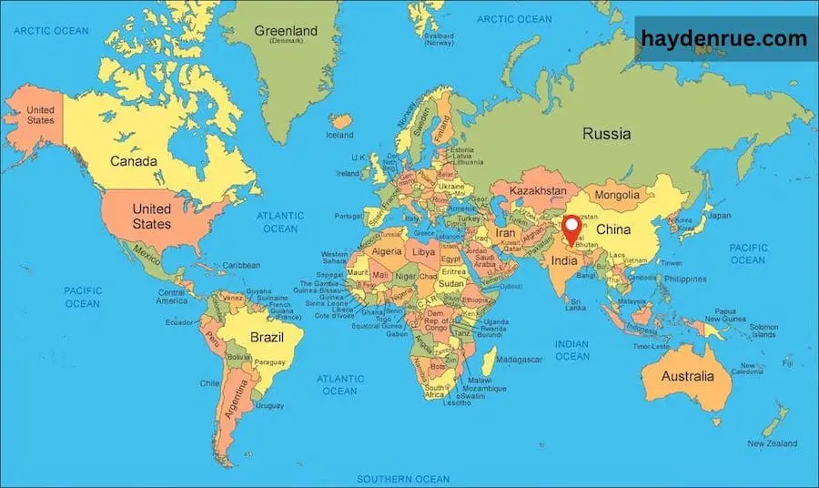
Without further ado, let’s have a look at the map from the widest angle and look at where Nepal is located on a world map.
Where is Nepal Located on a World Map?
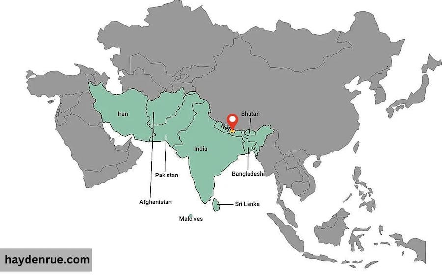
Nepal, or officially the Federal Democratic Republic of Nepal, is a landlocked country in South Asia. Surrounded by the two large geopolitical powers in China and India. Nepal is a small country with approximately 150,000 square kilometers of the land of which 20 percent is arable. Approximately 30 million people live in three distinct regions of the country – Mountains, Hills, and the Terai (see geographic map below).
The vast geographical range gives rise to both high and low altitudes – with the altitude in Nepal ranging from over 8,000 meters above sea level (Mount Everest) to the central hill region (1000-4000 meters above sea level) and finally down to the southern lowlands (Terai) which is below 1000 meters above sea level. Finally, the country even reaches 60 meters above sea level in Jhapa – the lowest point in all of Nepal!
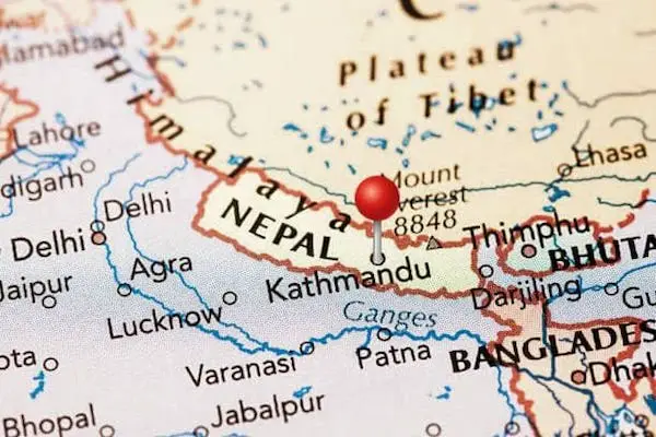
In the image below you can see exactly where Nepal is located. I have dropped a red pin on the location of Nepal:
Where is Nepal geographically located in Asia?
Nepal is located in Asia, and more specifically in South Asia. Nepal’s eastern, southern, and western border is shared with India. Moreover, the northern border is shared with China as well as what used to be the country of Tibet.
The border shared between Nepal and India, is mostly characterized by the Terai, which is the lowlands of Nepal and is relatively flat compared to the rest of the country. The northern border shared with China is completely opposite and is where the Himalayan range lies, which is where many of the tallest mountains in the world are located. Including the location of the summit of Everest!
There are other countries that are in close proximity to Nepal as well. They include Pakistan, Bhutan, and Bangladesh. If you increase the geographical range a little bit more from Nepal, you will also find Myanmar (Burma, Afghanistan, Sri Lanka, Maldives, and even Thailand). Many of these countries also have strong economic and political ties to one another because of their geographical placement and proximity to one another on the world map. Whereas, in 1985 the South Asian Association for Regional Cooperation (SAARC) was formed. It is an economic and political organization of eight countries in South Asia: Bangladesh, Bhutan, India, Maldives, Nepal, Pakistan, Sri Lanka, and Afghanistan (which joined in 2007).
The map below shows where Nepal is in terms of Asia on the world map. As you can see, Nepal’s geographical placement, sandwiched between two geopolitical powers in Asia, makes it a political hotspot, and of interest to many countries around the world.
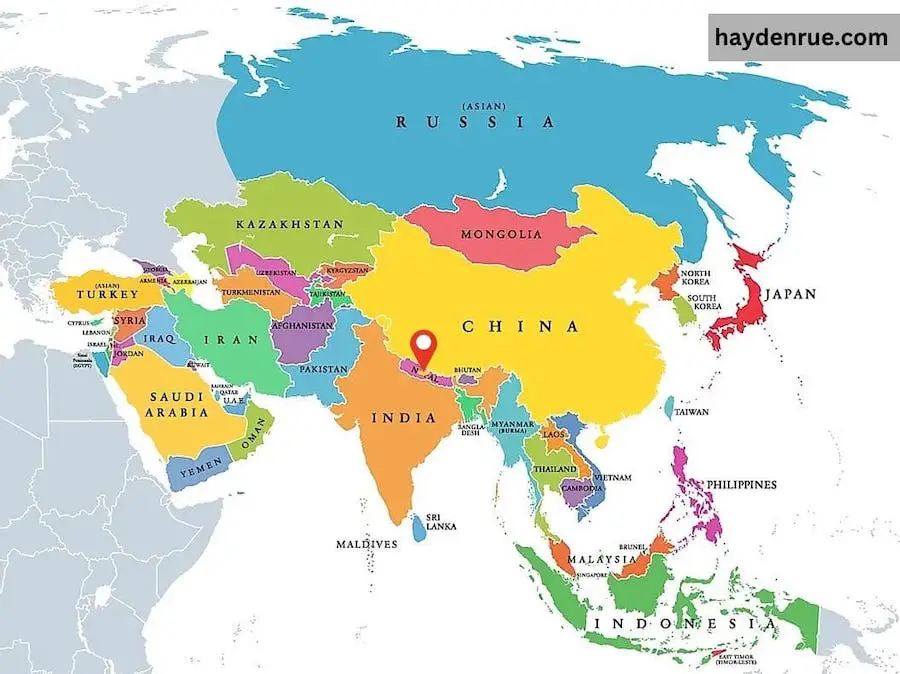
Asia has a total of 48 countries and has been broken up geographically into five sub-regions. Which are: Central Asia, East Asia, South Asia, Southeast Asia, and Western Asia. Nepal is located in South Asia. South Asia consists of nine countries in total, which include: Sri Lanka, Bangladesh, India, Afghanistan, Pakistan, Bhutan, Nepal, The Maldives, and Iran.
Nepal’s location in South Asia:
A map of South Asia and the nine countries that it consists of have been highlighted on the world map below:
Map of Nepal:
Now that we have a good understanding of where Nepal is on the world map, and in relation to other countries in Asia. I want to zoom in on the country itself and have a look at the different parts of the country, in terms of its geography, its environment, its political breakdown, and the population density of the country.
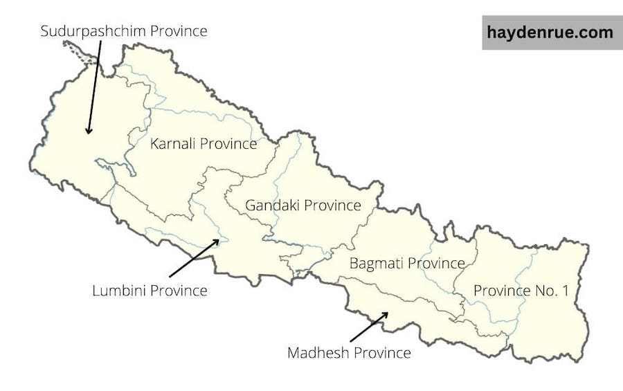
First let us look at the political boundaries of Nepal, and how it is broken apart into seven different provinces.
Provincial Map of Nepal:
Nepal has three levels of governance – federal, provincial and local. The federal capital of Nepal is Kathmandu, which is part of the Bagmati Province. There are a total of seven provinces in the country, which consists of 77 total districts and then finally a total of 753 local-level bodies.
The seven provinces are the second level of government, and function similar to how states function in the USA. Each province has its own geographical boundary and capital, to watch over the happenings of the different districts. The provincial map of Nepal can be seen in the image below:
The following table provides information about the seven provinces, their capital, number of districts, size in area, and population.
| Province Name | Capital | # of Districts | Area (km2) | Population (2011) |
|---|---|---|---|---|
| Province No. 1 | Biratnagar | 14 | 25,905 km2 | 4,534,943 |
| Madhesh Province | Janakpur | 8 | 9,661 km2 | 5,404,145 |
| Bagmati Province | Hetauda | 13 | 20,300 km2 | 5,529,452 |
| Gandaki Province | Pokhara | 11 | 21,504 km2 | 2,403,757 |
| Lumbini Province | Deukhuri | 12 | 22,288 km2 | 4,499,272 |
| Karnali Province | Birendranagar | 10 | 27,984 km2 | 1,570,418 |
| Sudurpashchim Province | Godawari | 9 | 19,915 km2 | 2,552,517 |
The table highlights the seven different provinces in Nepal and provides data on the number of districts in each as well as the population and total area of the province.
More information regarding the provinces and the political breakdown of Nepal can be seen in our Nepal Overview article.
Geographical Map of Nepal:
The following map of Nepal shows the different physical features of the country and how it is broken up into three distinct regions: mountains, hills, and lowlands. Moreover, it shows the elevations of each of the three areas and paints a good picture of how the elevation of Nepal quickly changes when traveling north to south in the country.
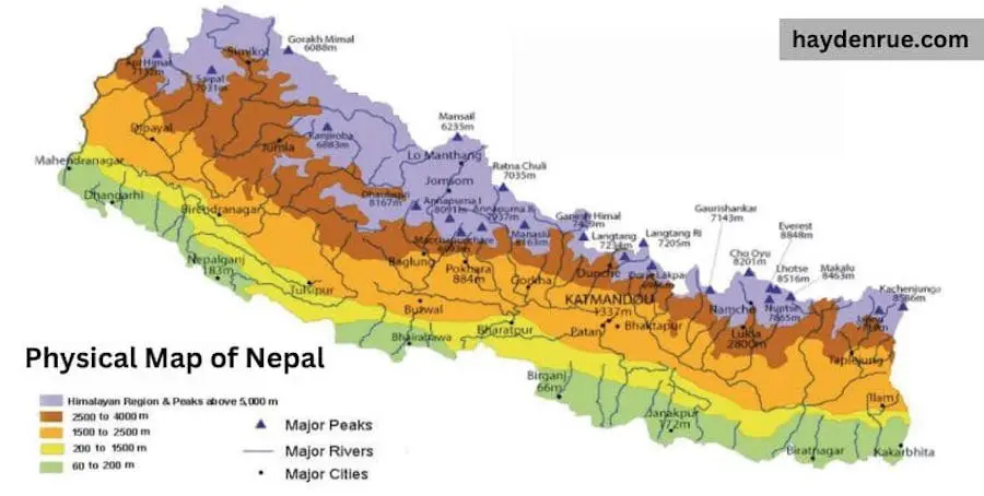
Nepal is a difficult country to travel in because of the fluctuations in elevation. The country has many high hills and deep valleys that travelers must navigate through to get to their destination. However, this terrain is a blessing in disguise as it gives rise to vastly different ecosystems and an array of different flora and fauna. According to the National Trust for Nature Conservation, Nepal occupies only 0.1 percent of the global area, but harbors over three percent and one percent of the world’s known flora and fauna, respectively. Nepal’s biodiversity profile records 208 mammals, 867 birds, 123 reptiles, 55 (+-) amphibians, 230 freshwater fish, and 651 butterfly species! Making the country highly diverse, and a great place to visit!
Additionally, the terrain gives rise to some of the tallest mountains in the world, like Mount Everest and the Annapurna Range. These mountains provide great trekking opportunities in Nepal for adventure seekers! Some of the most common trekking routes in the country are the Everest Base Camp trek and the Annapurna Base Camp trek!
Map of Major Nepali Cities:
Nepal’s major cities include the Kathmandu Valley (Kathmandu, Lalitpur, and Bhaktapur), Pokhara, and Chitwan. These three locations attract many tourists and are the economic hubs of the country. That being said, there are many other cities throughout the country that are worth visiting! If you are looking to travel in Nepal and want to find out what the beautiful country has to offer, have a look at our places to visit in Nepal blog!
Below is a map of the major cities in Nepal:
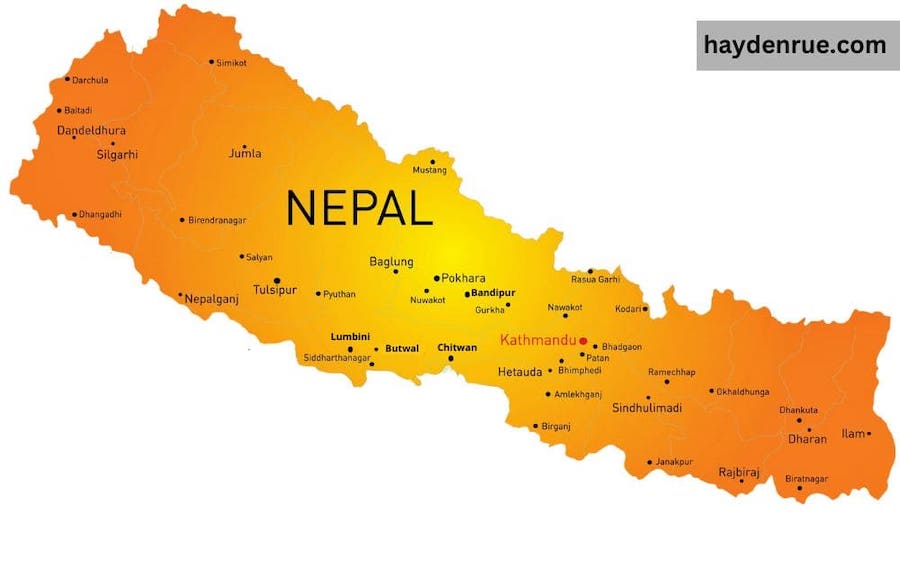
In the map above you can see where the capital of the country, Kathmandu is located. It can be found in the Kathmandu valley along with Lalitpur and Bhaktapur. Moreover, Kathmandu is in the central and slightly eastern parts of the country. It is found in the mid-hills of Nepal, and the whole city sits in a geographic bowl with hills surrounding the entire city. Kathmandu is also where the two rivers – Bagmati River and the Bishnumati River – meet. Finally, the city is surrounded by mountains to the north and at high enough elevations you can get a panorama view of all of the Himalayas. One great way to see the mountains in all their glory is to check out the best hikes in Kathmandu blog! The main city is at an elevation of 1,370 meters above sea level, and it is divided into two parts: the new city and Kathmandu’s ancient old city.
Want more information about elevation in Nepal? Check out my blog covering the elevation of major cities in Nepal!
Kathmandu is the biggest city in Nepal and has the highest population density out of the entire country. However, it is also important to look at some of the other large cities in the country. The table below highlights the major metropolitan cities of Nepal, as well as their population. As you can see from the information, many of the major cities can be found in the Bagmati province.
| Metropolitan City | City in Nepali | District | Province | Population (2021) | Area (km2) |
|---|---|---|---|---|---|
| Kathmandu | काठमाडौँ | Kathmandu | Bagmati | 845,767 | 49.45 |
| Pokhara | पोखरा | Kaski | Gandaki | 518,452 | 464.28 |
| Bharatpur | भरतपुर | Chitwan | Bagmati | 369,377 | 432.95 |
| Lalitpur | ललितपुर | Lalitpur | Bagmati | 299,843 | 36.12 |
| Birgunj | वीरगंज | Parsa | Madhesh | 268,273 | 132.07 |
| Biratnagar | विराटनगर | Morang | Province No. 1 | 244,750 | 77.00 |
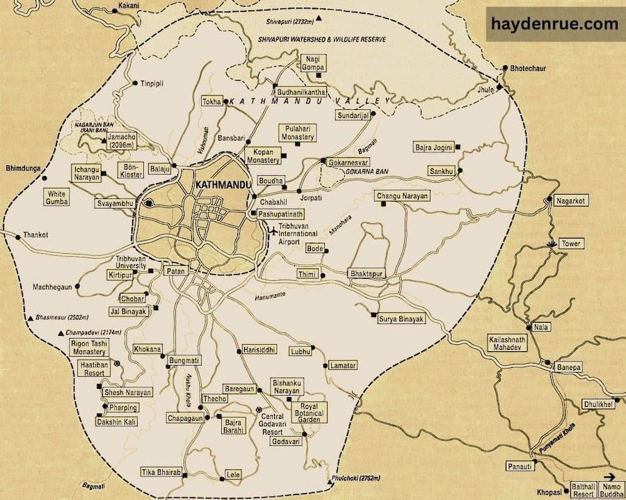
Map of Kathmandu:
The final map from Nepal that I want to include in this article is a map of Kathmandu. Kathmandu currently has the only operational international airport in the country. Moreover, it is known as the city of temples and is an important city in terms of culture and heritage. With temples around every corner and a diverse population, you can find everything you are looking for in the capital of Nepal.
Interested in temples in Nepal? Check out our roundup of famous temples in Nepal you have to see!
In the map below, we have highlighted some of the major areas of the city. They include temples, hiking destinations, restaurants, and other points of interest for tourists and travelers to visit!