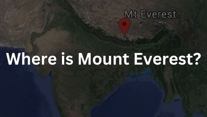
Mount Everest is located in the Himalayan mountain range and part of the Khumbu Himal. Specifically, the tallest mountain in the world is located on the border between Nepal and Tibet (Autonomous region of China). Overall Everest is part of the Himalayas that stretch across several countries in South Asia.
This blog covers everything related to the location of Mount Everest. Including in the world, in Asia and in relation to the Himalayan mountain range.
Where is Mount Everest located?
Mount Everest is located in the Himalayan mountain range on the border of Nepal and Tibet, (Autonomous region of China). Everest in Nepal is positioned at latitude 27.986065 and longitude 86.922623. The peak falls in Nepal with GPS coordinates of 27° 59′ 9.8340” N latitude and 86° 55′ 21.4428” E longitude.
Map of Everest Location:
The map below shows the location of Everest from the south side. It includes the location of: Everest Base Camp, Everest Camp I, Everest Camp II, Everest Camp III, Everest Camp IV, and the summit of Everest.
Additionally, the exact Mount Everest location as defined by China and Nepal, have the following locations:
- Mt. Everest’s Location in China: Tingri County, Xigazê, Tibet Autonomous Region, China
- Mt. Everest’s Location in Nepal: Solukhumbu District, Koshi Province, Nepal
The precise position of Mount Everest’s summit on the international border is clearly depicted on detailed topographic maps, including official Nepali mapping. If you want to learn more, check out our blog about where Nepal is in the world!
Everest Region and Surrounding Mountains:
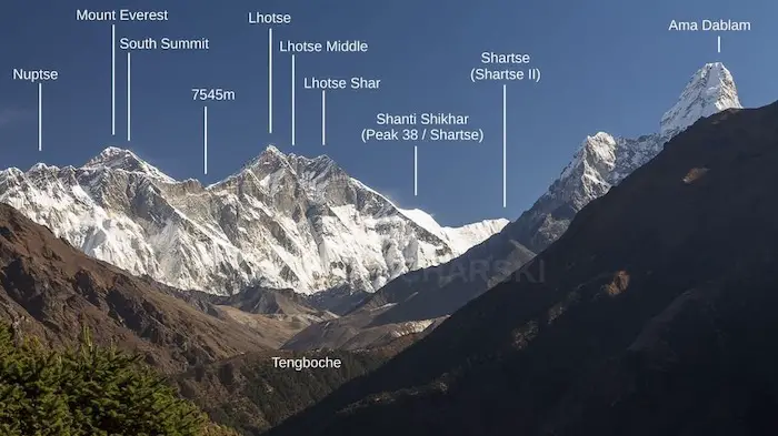
The Everest Region, or Khumbu Himal region is situated in the eastern part of Nepal, just south of the border with China. The Khumbu Himal boasts a collection of the world’s tallest mountains. Among these majestic peaks is Mt. Everest, also known as Sagarmatha in Nepali and Chomolungma in Tibetan, soaring to a height of 8,848 meters, making it the highest point on the planet.
This iconic region is also home to several other towering peaks, including Lhotse (8,516 meters / 27,940 feet) and Cho Oyu (8,188 meters / 26,864 feet). Sagarmatha National Park, a UNESCO World Heritage Site includes these mountains and covers an area of approximately 1,148 square kilometers (443 square miles). The heritage site serves to protect the diverse ecosystems, featuring rugged terrain, alpine meadows, and dense forests of the mountain.
The region’s unique geography includes the deadly Khumbu Icefall, a hazardous glacier requiring careful navigation for mountaineers attempting to reach Everest’s summit. Everest Base Camp, situated at an altitude of around 5,380 meters (17,600 feet), serves as the starting point for most expeditions to the world’s highest peak.
Below is an image of additional peaks in the vicinity of Everest.
Moreover, an interactive Google Map of the Everest region and important mountains, regions and locations have been marked.
Mount Everest’s Location in the Himalayas:
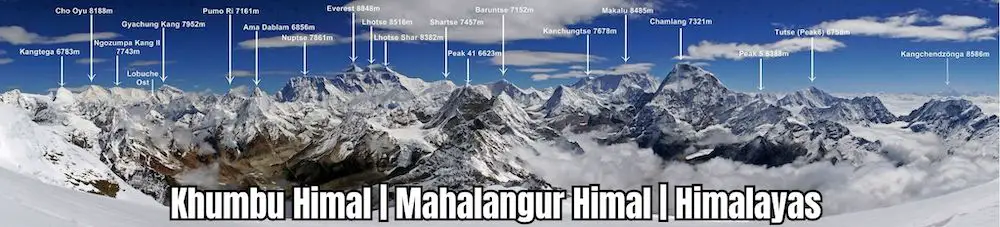
Mount Everest is situated in the Mahalangur Himal, which is the highest sub-range within the Himalayas. This iconic peak is encircled by over 40 other mountains, all towering above 7,000 meters in altitude.
The Mahalangurs’ famous Himalayan peaks with with world ranking of height:
- #1 Mount Everest (8,848 m/29,029 ft)
- #3 Kanchenjunga (8,586 m/28,169 ft)
- #4 Lhotse (8,516 m/27, 939 ft)
- #5 Makalu (8,463 m/27,765 ft)
- #6 Cho Oyu (8,201m/26,906 ft)
- #7 Dhaulagiri (8,167 m/ 26,794 ft)
- #8 Manaslu (8,163 m/26,781 ft)
- #10 Annapurna (8,091 m/26,545 ft).
Everest Location in Nepal:
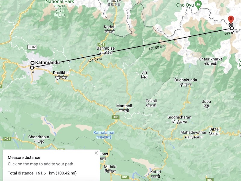
Reaching the Nepalese side of Everest is relatively less restricted compared to the north side. The iconic peak is located approximately 200 km (120 miles) east of Kathmandu, but the road journey can be challenging. Therefore, most people opt to take a flight to Lukla instead.
Villages along the Everest Base Camp Trek:
Once you have entered the Khumbu region, either by jeep or plane, you will begin the Everest Base Camp Trek. The information below traces the most famous locations and areas along the route leading to Everest.
1. Lukla: Gateway to Everest
Lukla, is a small town located in the Khumbu Pasang Lhamu rural municipality of the Solukhumbu District in Province No. 1, northeastern Nepal. Positioned at an elevation of 2,860 meters (9,383 feet), it serves as the gateway for visitors heading to the Himalayas, particularly those aiming to explore Mount Everest and its surrounding region.
2. Phakding and Monjo:
Phakding and Monjo are popular overnight stops along the trail to Everest, positioned on the Dudh Koshi riverbank. The town of Phakding serves as the first overnight stop in the region and Monjo is the entry point to Sagarmatha National Park. Which are common places to stay overnight on the return journey from the base camp.
3. Namche Bazaar: The Sherpa Capital
Namche Bazaar is the financial hub of the Everest region, situated at 3,440 meters above sea level. It offers modern town facilities and serves as both an overnight stop and the first acclimatization point for trekkers heading to Everest base camp.
4. Tengboche: Cultural Center
Tengboche, nestled at an altitude of approximately 3,867 meters (12,687 feet), is a village and cultural center in the Everest region of Nepal. It is home to the iconic Tengboche Monastery, a revered Buddhist monastery that holds immense spiritual importance for the local Sherpa community. The monastery’s rich history, intricate architecture, and proximity to Everest make it a popular destination to visit.
5. Dingboche: Second Acclimatization Point:
Dingboche, located at an elevation of 4,410 meters (14,469 feet), is the second acclimatization point along the EBC Trek. Trekkers spend two nights here to allow their bodies to adapt to the thinning air at higher altitudes. Dingboche offers panoramic views and provides trekkers with a sense of remoteness and serenity before venturing further towards Everest Base Camp.
6. Lobuche and Gorakshep:
Lobuche, situated at around 4,940 meters (16,207 feet), and Gorakshep, at approximately 5,164 meters (16,942 feet), offer trekkers a taste of the rugged mountain wilderness. These remote and picturesque settlements provide basic accommodations and serve as resting points for trekkers in their final approach to Everest Base Camp.
7. Khumjung and Pangboche:
Khumjung and Pangboche are culturally rich centers that showcase the unique heritage and traditions of the Everest region. Situated at elevations of around 3,790 meters (12,434 feet) and 3,985 meters (13,074 feet), respectively, these villages offer trekkers a glimpse into the Sherpa way of life.
Geology and Formation of the Himalayan Range:
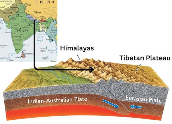
Mount Everest, holds a prominent position within the Himalayan range, the world’s highest mountain system. Geologically, Everest is primarily composed of sedimentary and metamorphic rock formations that were formed millions of years ago during the collision of the Indian and Eurasian tectonic plates. The region’s geological history is marked by intense tectonic activity, which has led to the uplifting of the Himalayas to their towering heights.
Geologists have categorized the rocks forming Mount Everest into three distinct formations, each separated by low-angle faults known as detachments. These geological units have been thrust southward over one another, creating the mountain’s intricate structure. Starting from the summit and descending to its base, the rock units are identified as the Qomolangma Formation, the North Col Formation, and the Rongbuk Formation.
Due to the uplifting caused by the Indian and Eurasian tectonic plates, there are numerous other notable peaks surrounding Everest. Some of these neighboring giants include Lhotse, the fourth-highest peak globally, Nuptse, Makalu, and Cho Oyu, each exceeding 8,000 meters in height. These peaks, along with Everest, form a formidable mountain landscape.
Standard Routes of Everest Climbing:
The Standard Routes for climbing Mt. Everest includes the North Route from Tibet (China) and the South Route from Nepal.
1. North Route from Tibet:
The North Route starts on the Tibetan side of Everest and is often regarded as the more technically challenging of the two routes. Climbers begin their journey from the base camp on the north side, which sits at an elevation of approximately 5,200 meters (17,060 feet). They then proceed to intermediate camps, including Advanced Base Camp (ABC) and the North Col, where they acclimatize and prepare for the ascent.
The route features several obstacles, including the infamous Second Step, a near-vertical rock wall that requires climbers to use ropes and ladders to navigate. The final push takes climbers to the summit through the northeast ridge, where they encounter high altitudes, extreme weather conditions, and icy terrain. Despite the technical challenges, the North Route provides stunning views of the Tibetan Plateau and surrounding peaks.
2. South Route from Nepal:
The South Route, originating from the Nepalese side, is the more popular and widely used path to reach the summit of Everest. Climbers start their journey from the South Base Camp, situated at an elevation of around 5,364 meters (17,598 feet). From there, they proceed through the Khumbu Icefall, a dangerous section of moving ice seracs, crevasses, and ladders.
After crossing the Icefall, climbers reach Camps 1 and 2 at higher altitudes for acclimatization. The route then leads to Camp 3 on the Lhotse Face and Camp 4 on the South Col, where climbers prepare for their summit attempt. The final ascent is via the Southeast Ridge, which includes the challenging Hillary Step, a steep rock face just below the summit.
The South Route is favored for its accessibility, logistical support, and relatively safer passage through the Khumbu Icefall compared to the North Route. Climbers on this route are rewarded with breathtaking views of the Khumbu Valley and the surrounding Himalayan peaks.
The Fascination of Conquering Everest:
Mount Everest, situated on the border between Nepal and China’s Tibet Autonomous Region is a magnet for climbers and adventurers worldwide. The existence of the mountain has been known for centuries, but it gained significant attention in the mid-19th century during the British Survey of India. The mountain was initially identified as “Peak XV” by British surveyor Sir George Everest in 1841, who was in charge of mapping the region.
The first successful ascent of Mount Everest was achieved on May 29, 1953, by Sir Edmund Hillary of New Zealand and Tenzing Norgay, a Sherpa of Nepal. They were part of a British expedition led by Colonel John Hunt. The historic achievement marked a momentous milestone in mountaineering history and brought global recognition to Everest as the once most sought after unconquered peak.
However, their achievement also brought on the beginning of the commercialization of Everest. With more and more climbers attempting Everest every year, it has become overcrowded and at times dangerous to climb.
Not only has the increasing number of climbers led to disaster and death on Sagarmatha, it has also caused a significant problem with trash on Mount Everest. The mountain’s slopes and camps have become littered with discarded climbing gear, oxygen cylinders, and other waste, posing environmental concerns.
Climbing Everest is an extraordinary feat that demands extensive mountaineering experience, physical fitness, and mental strength. The journey is known for its difficulties, including deadly crevasses, unpredictable weather, and the risks associated with high altitudes. Altogether, making it one of the most challenging and dangerous climbs in the world.
Nepal and Tibet: Geographically Blessed
Mt. Everest, Earth’s highest peak, is located on the border between Nepal and China’s Tibet Autonomous Region. Although summiting Everest is extremely difficult, thousands of climbers still trek every year into the Khumbu region of Nepal to see the impressive mountain.
The region’s geological history, shaped by tectonic activity and ancient rock formations, contributes to the mountain’s unique character and allure. Geographically blessed, Nepal as well as Tibet are home to some of the tallest mountains in the world such as Everest, Lhotse, Nuptse, Makalu, and Cho Oyu.
FAQs: Mount Everest Location
Below are the most frequently asked questions regarding the location of Everest in the world.
Mount Everest is located on the border of China and Nepal. In both political and geographical terms, Everest is co-owned by the two nations. The mountain is split into two sections, commencing from its summit, with the southern slope belonging to Nepal and the northern slope to China.
Yes, Everest is visible from India on the Sandakphu Phalut trek. Sandakphu has an altitude of 11,930, allowing you to see the Everest cluster. The town of Molley on the trek also provides views of the mountain.
Mount Everest is located in the continent of Asia. It is situated in the great Himalayas, which stretch across several countries in South Asia, including Nepal and China.