Mount Everest has two primary climbing routes: the southeast ridge originating from Nepal and the north ridge from Tibet. There are also several less-frequented paths. Between the two main routes, the southeast ridge is considered less technical. Moreover, the route sees more frequent usage than the route from China.
However, the choice of the South Col route was influenced more by political circumstances than intentional planning. In the 1950s, the Chinese border remained closed to the western world after the People’s Republic of China’s invasion of Tibet.
While it might be an overstatement to claim that all possible routes on Everest have been conquered, a new generation of climbers continuously manages to forge new paths. Nevertheless, extensive exploration has resulted in the identification of approximately 20 distinct routes, most of which have been attempted at least once.
However, two routes remain unclimbed to this day. The first is a direct ascent via the East Face, and the other is known as the Fantasy Ridge or the East Ridge. Both paths pose immense dangers and are prone to avalanches.
Different Climbing Routes of Everest
Broadly speaking, there are approximately 20 recognized climbing routes mapped on Mount Everest.
Mount Everest has three distinct faces for climbers: the Southwest Face from Nepal, the East Face also known as the Kangshung Face, from Tibet, and the North Face, also from Tibet. Among these, the Kangshung Face has witnessed the fewest attempts and an even smaller number of successful summits.
The majority of attempts to summit Everest occur in May, before the onset of the summer monsoon season. As the monsoon season approaches, the jet stream shifts northward, resulting in reduced average wind speeds at higher altitudes on the mountain.
While some attempts are occasionally made in September and October, after the monsoons when the jet stream is temporarily pushed northward again, the snow from the monsoons and the less stable weather patterns make climbing exceptionally challenging.
Non Standard Routes and Their Variations
Numerous variations of non-standard routes exist on Mount Everest. For instance, climbers may ascend via the standard Northeast Ridge to the summit and return via the Great Couloir or the North Face. Another well-liked option is the Southwest Face, which encompasses both the Bonington Route and a climb via the Rib.
On the north side, most climbers follow the Northeast Ridge route, but, in truth, they join the ridge midway. The authentic ascent of the true Northeast ridge took place in 1995, achieved by a Japanese team who initiated their journey at roads end at 5,150 meters. An especially challenging section of this route, known as The Three Pinnacles, demanded extensive technical skill and effort. The team spent three days and laid 1,250 meters of fixed rope to navigate through this section successfully.
When it comes to how many people have summited Everest from each route, as of December 2021, out of the 10,656 summits, only 254 (191 members and 63 hired) opted for “non-standard” routes. However, these alternative routes accounted for 81 (51 members and 30 hired) of the total deaths on Everest, representing 27% of all fatalities. This explains, in part, why commercial operators primarily favor the standard routes due to lower risks involved.
Faces of Mount Everest
Here’s a compilation of Everest’s faces along with their common names and designations used in the Himalayan Database.
The credit for illustrations in this blog belongs to National Geographic, courtesy of Martin Gamache, Jaime Hritsik, Chiqui Esteban, and the NG Staff, The American Alpine Journal, The Himalayan Database, Ed Webster, East Face Imagery Courtesy Of Digital Globe @ 2012, and Raphael Slawinski.
North Face Routes on Everest:
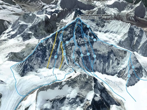
- (J) Integral Northeast Ridge – Established in 1995 by a Japanese Team.
- (L) Russian Couloir – Conquered by a Russian team in 2004.
- (K) The Complete Northeast Ridge, North-Northeast – Climbed by Messner solo in 1980, an Italian route.
- (N) American Direct – Achieved by an American expedition in 1984.
- (O) The Great Couloir aka Norton Couloir (White Limbo) – Scaled by an Australian team in 1984.
- (P) Russian Direct – Conquered by a Russian team in 2004.
- (Q) Japanese Supercouloir – Established by a Japanese team in 1980.
- (A) West Ridge Direct – Successfully completed by a Yugoslavian team in 1979.
- (R) Canadian Variation – Accomplished by a Canadian expedition in 1986.
East Face Routes on Everest:
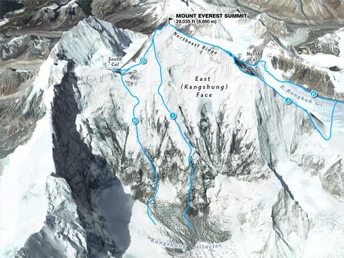
- (H) East Face-South Col: Neverest Buttress – Scaled by an international team in 1988.
- (I) Southwest Pillar, East Face: American Buttress – Achieved by an American team in 1983.
- (J) Integral Northeast Ridge – Conquered by a Japanese team in 1995.
- (K) North Ridge/Northeast Ridge – Established by a Chinese expedition in 1960.
Southwest Face Routes on Everest:
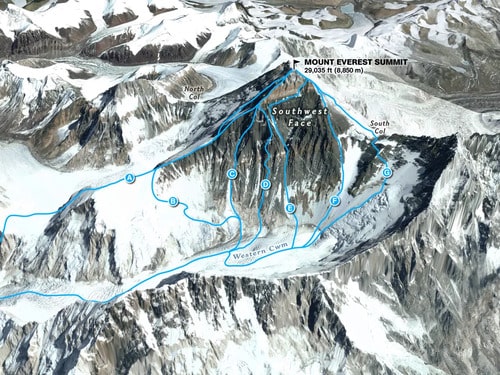
- (A) American West Ridge – Pioneered by an American team in 1963.
- (C) Korean (Park) – Conquered by a South Korean team in 2009.
- (D) Russian Buttress – Achieved by a Soviet team in 1982.
- (E) Southwest Face – Successfully climbed by a British team in 1975.
- (F) South Pillar – Scaled by a Polish expedition in 1980.
- (G) South Col – First accomplished by a British team in 1953.
Standard Routes:
The location of Everest and its geology allows for two main routes. A staggering 10,402 out of the total 10,656 summits have followed the same fundamental paths. The first route, pioneered by the British expedition in 1953, takes the Southeast Ridge-South Col approach, while the second route led by Shi Zhang in 1960 involves the Northeast Ridge-North Col.
Currently, these routes have become entangled in guide politics, sparking debates over safety, difficulty levels, and the likelihood of success. Both sides present convincing arguments for their preferred climbing approach.
Southeast Ridge – South Col Route
| Advantages | Disadvantages |
| Scenic trek to base camp in the Khumbu region | Instability of the Khumbu Icefall |
| Convenient access to villages for pre-summit recovery | High presence of crowds, particularly on summit night |
| Helicopter rescue available from as high as Camp 3 at 23,500′ if needed | Exposure to the dangers of Cornice Traverse |
| Occasional warmer weather with reduced winds | Slightly longer duration for summit night |
Northeast Ridge – North Col Route
| Advantages | Disadvantages |
| Lesser crowd compared to the Nepal side | Harsher temperatures and more severe winds |
| Accessible by vehicle to base camp | Camps situated at higher elevations |
| Relatively easier climbing to mid-level camps | Slightly increased difficulty due to smooth or loose rocks |
| Slightly shorter summit night | Absence of helicopter rescue option at any point |
Southeast Ridge – South Col Route
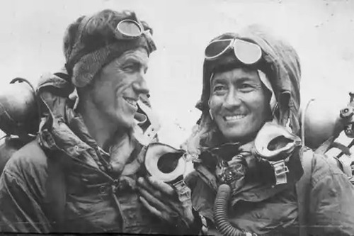
Tenzing Norgay and New Zealander Edmund Hillary, achieved the first successful summit of Mt. Everest. They used the South Col route, which had only been attempted twice before by Swiss teams in 1952 during the spring and autumn seasons. During the Swiss expeditions, their teams managed to reach an altitude of 8,500 meters, well above the South Col.
Notably, Norgay had prior experience with the Swiss team, which greatly contributed to his expertise during the British expedition. Subsequently, in 1956, the Swiss returned to make the second successful summit of Everest.
The following is a typical climbing schedule for the south side, indicating average times and distances from the previous camp, along with brief descriptions of each section.
Climbing Itinerary for Everest’s South Side:
1. Trekking Peak Acclimatization: Lobuche 20,161′:
Many teams now include Lobuche as part of their acclimatization process, reducing one trip through the Icefall.
2. Basecamp – 17,500’/5334m:
The base camp rests on a moving glacier, with tents often shifting and platforms melting. Despite the harsh surroundings, the area offers stunning views of Pumori and the Khumbu Icefall. The multitude of expedition tents, pathways, and generators create a small village atmosphere.
3. Camp 1 (C1): 19,500’/5943m – 4-6 hours, 1.62 miles:
The climb to C1 can be dangerous due to the Khumbu Icefall, a 2,000-foot expanse of moving ice, which moves up to 3 feet per day along the edges. The primary hazards, stems from the deep crevasses, towering ice seracs, and avalanches Everest’s shoulder.
4. Camp 2 (C2): 21,000’/6400m – 2-3 hours, 1.74 miles
The trek from C1 to C2 involves crossing the Western Cwm, a section laden with crevasse dangers. Additionally, climbers contend with extreme heat, making the ascent challenging. Avalanches from Everest’s West Shoulder have also been known to affect C1 in recent years.
5. Camp 3 (C3) nm: 23,500’/7162m – 3-6 hours, 1.64 miles
Climbing the Lhotse Face to C3 can prove difficult, as most climbers feel the effects of high altitude and are yet to use supplemental oxygen. The steep Lhotse Face requires fixed ropes and features angles ranging from 20 to 45 degrees. Despite the demanding ascent, most teams acclimatize at C3 before attempting the summit.
6. Yellow Band – 3 hours
The route to the South Col starts at C3 and passes through the Yellow Band. Though the initial section is steep, it settles into a sustained grade as the altitude increases. Climbers wear down suits and start using supplemental oxygen for the first time. While the Yellow Band’s limestone rock is not particularly challenging, the altitude can make it difficult. Bottlenecks are common in this area.
7. Geneva Spur – 2 hours
The top of the Geneva Spur leading to the South Col features some of the steepest climbing so far. Climbing becomes more manageable with a good layer of snow compared to loose rocks.
8. South Col: 26,300’/8016m – 1 hour or less
The South Col resembles the moon’s surface, flat and covered with loose rocks. Surrounded by Everest to the north and Lhotse to the south, climbers cluster tents together and secure them with nets or heavy rocks to withstand hurricane-force winds. The South Col serves as the staging area for summit bids and the high point for Sherpas to ferry oxygen and gear for the final ascent.
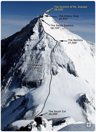
9. Balcony: 27,500’/8400m – 4-5 hours
At the Balcony, climbers officially start using supplemental oxygen to ascend the steep and sustained route up the Triangular Face. Climbers form a long conga line of headlamps in the dark. The pace can be slow, with stops for rest and contemplation of whether to continue to the balcony or turn back.
The conditions on the Triangular Face can vary between rock and snow, and rockfall poses a serious danger, leading some climbers to use helmets. Oxygen bottles are swapped at the Balcony, where climbers take a short break for food and water.
10. South Summit: 28,500’/8690m – 3-5 hours
The climb from the Balcony to the South Summit is steep and continuous, representing the most technical section on this side of Everest. While a beaten-down boot path eases most of the ascent, the area near the South Summit can be challenging, particularly in low-snow years, with exposed slabs of smooth rock.
11. Hillary Step – 1 hour or less
The Hillary Step, one of the most exposed sections of the south side climb. It requires crossing the cornice traverse between the South Summit and the Hillary Step. The route is fixed and wide enough that climbers rarely encounter issues.
The Hillary Step was altered by the 2015 earthquake, resulting in a large snow bulb area instead of a short 40-foot section of rock climbing that was previously a bottleneck on crowded summit nights. Nonetheless, the current ‘Hillary Slope’ can still cause bottlenecks.
12. Summit: 29,035’/8850m – 1 hour or less
The last section from the Hillary Step to the summit is a moderate snow slope.
13. Return to South Col: 4-7 hours
Descending from the summit requires careful attention to avoid misplaced steps down the Hillary Step, the Cornice Traverse, or the slabs below the South Summit. Monitoring oxygen levels and supply diligently is crucial to ensure that oxygen lasts back to the South Col.
14. Return to C2: 3 hours
Climbers, often tired but relieved, return to the higher natural oxygen levels at C2, regardless of their summit performance. The descent can be quite hot, as many climbers still wear their down suits.
15. Return to Basecamp: 4 hours
Climbers begin their descent back to Basecamp. With temperatures in Everest now rising in June, the snow becomes mushy, increasing the difficulty.
Northeast Ridge Route
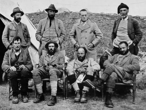
The north side of Everest boasts a rich history, with multiple attempts made during the 1920s and 1930s. The first British team’s reconnaissance expedition in 1921, led by George Mallory, marked the first human footsteps on the mountain’s flanks, reaching the North Col (7003m). The 1922 British expedition reached 27,300′ before retreating, becoming the first team to utilize supplemental oxygen. Tragically, the expedition experienced the first reported deaths when an avalanche claimed the lives of seven Sherpas.
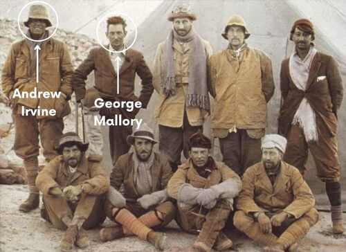
The 1924 British expedition, featuring George Mallory and Andrew “Sandy” Irvine, remains shrouded in mystery as to whether they reached the summit or not. Their potential summit, if confirmed, would precede Tenzing and Hilary’s achievement by 29 years. In 1999, Mallory’s body was discovered, but there was no definitive evidence to determine if he perished while ascending or descending.
On May 25, 1960, a Chinese team successfully made the first summit from Tibet. Nawang Gombu (Tibetan) and Chinese climbers Chu Yin-Hau and Wang Fu-zhou claimed the honor. Wang Fu-zhou is famously known to have climbed the Second Step in his sock feet. In 1975, during a successful summit expedition, the Chinese installed a ladder on the Second Step.
Tibet remained closed to foreigners from 1950 to 1980, preventing further attempts until a Japanese team summited in 1980 via the Hornbein Couloir on the North Face.
In the mid-1990s, the north side started gaining more attention from climbers and is now almost as popular as the south side when the Chinese authorities permit expeditions. However, obtaining permits became difficult in 2008 and 2009, limiting many expeditions from attempting routes from Tibet. Additionally, Tibet was closed to foreigners in 2020 and 2021 due to the COVID pandemic.
The following is a typical climbing schedule for the northeast ridge side, indicating average times and distances from the previous camp, along with brief descriptions of each section.
Climbing Itinerary for Everest’s North Side:
1. Basecamp: 17,000’/5182m
Located on a windy gravel area near Rongbuk Monastery, this is the starting point for vehicle-assisted evacuations. As of 2021, there are no helicopter rescues or evacuations available on the north side or for any mountain in Tibet.
2. Interim Camp: 20,300’/6187m – 5 to 6 hours (first time)
Used during the first acclimatization trek to Advanced Base Camp (ABC), this spot features a few tents and is typically lightly snow-covered or snow-free.
3. Advanced Base Camp (ABC): 21,300’/6492m – 6 hours (first time)
Many teams use ABC as their primary camp during acclimatization, but it’s situated at a high altitude. Despite its harsh environment, ABC offers a stunning view directly at the North Col.
4. North Col or Camp 1 (C1): 23,000’/7000m – 4 to 6 hours (first time)
Climbers traverse the East Rongbuk Glacier, donning crampons for the first time and using fixed lines and ladders over deep crevasses. The ascent gains altitude, including a steep 60-degree section. Several nights are spent at the Col during the expedition.
5. Camp 2 (C2): 24,750’/7500m – 5 hours
A steep and snowy ridge climb that transitions to rock. High winds can make this a cold climb. Some teams use C2 as their highest acclimatization camp.
6. Camp 3 (C3): 27,390’/8300m – 4 to 6 hours
C3 is positioned on steep, rocky, and exposed sections of the ridge. Now using supplemental oxygen, climbers contend with strong winds and harsh conditions. This point serves as the launching spot for the summit bid.
7. Yellow Band
Climbers follow a fixed rope through a snow-filled gully, part of the Yellow Band, before reaching the northeast ridge.
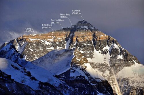
8. First Step: 27,890’/8500m
The first of three rock features. Climbers rate it as steep and challenging, requiring good footwork and steady use of the fixed rope in the final gully to the ridge.
9. Mushroom Rock: 28,047’/8549m – 2 hours from C3
A rock feature used as a marker of progress on summit night. Oxygen is swapped here. The route can be filled with loose rock, adding to the difficulty with crampons.
10. Second Step: 28,140’/8577m – 1 hour or less
This is the crux of the climb with the Chinese Ladder. Climbers ascend a 10′ rock slab then climb a near-vertical 30′ ladder, very exposed with a 10,000′ vertical drop.
11. Third Step: 28,500’/8690m – 1 to 2 hours
The third step is considered to be the easiest of the three steps.
12. Summit Pyramid – 2 to 4 hours
A steep, windy, and bitterly cold snow slope. Climbers feel extremely exposed navigating around a large outcropping and experiencing three more small rock steps before the final ridge climb to the summit.
13. Summit: 29,035’/8850m – 1 hour
The final 500′ horizontal distance along the ridge to the summit is quite exposed, with slope angles ranging from 30 to 60 degrees.
14. Return to Camp 3: 7-8 hours
Descending follows the same route, with potential delays at the Second Step.
15. Return to ABC: 3 hours
Packs can be heavy as everything hauled up must be taken back down. The warmer June temperatures make the snow mushy, increasing the difficulty.
Everest Statistics and Price:
According to the Himalayan Database up to December 2021, there have been a total of 10,656 summits on Mount Everest, involving 6,098 different individuals, comprising 5,351 members and 5,305 hired personnel.
The Nepal side has been more popular with 7,023 summits compared to 3,633 summits from the Tibet side. Approximately 2.1% of climbers, amounting to 216 individuals, reached the summit without using supplemental oxygen. Furthermore, 35 climbers have successfully traversed from one side to the other.
Overall, around 62% of all expeditions succeeded in placing at least one member on the summit. Impressively, 621 climbers have summited from both Nepal and Tibet, while 135 climbers accomplished multiple summits in a single season, with 67 of them summiting within a seven-day timeframe of their first ascent that season. Additionally, 640 people have summited from both the Nepal and Tibet side.
Tragically, from 1924 to December 2021, a total of 305 people lost their lives on Everest, comprising 186 westerners and 119 Sherpas, representing approximately 3.5% of all climbers. Most of the deceased climbers’ bodies remain on the mountain, though China has removed numerous bodies from sight on their side. The primary causes of death include avalanches (77), falls (71), altitude sickness (35), and exposure (26).
Cost to Climb Mount Everest:
Climbing Mount Everest is a costly endeavor due to various expenses involved in preparation, logistics, and support. The total cost to climb Everest can vary depending on several factors such as the chosen route, the level of support, the length of the expedition, and the quality of services provided. On average, the cost to climb Everest ranges from $45,000 to $100,000 or even more.
The major components contributing to the cost include:
- Expedition Fees: The largest portion of the cost is the expedition fee charged by the organizing company or guiding service. This fee typically covers permits, climbing support, logistics, and base camp services.
- Logistics: This includes travel expenses to and from Nepal or Tibet, accommodation in Kathmandu or Lhasa, and other logistical arrangements.
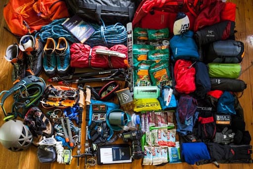
- Gear and Equipment: Climbers need specialized mountaineering gear, clothing, and equipment designed for extreme conditions, which can be expensive.
- Sherpa Support: Many climbers hire Sherpas as guides and support staff to assist with carrying loads, setting up camps, and providing guidance on the mountain.
- Climbing Permits: The Nepalese government charges a significant fee for climbing permits, and this cost increases with the height of the peak.
- Oxygen: Many climbers use supplemental oxygen for higher altitudes, and the cost of oxygen bottles and their transportation can add to the overall expense.
- Training and Preparation: Preparing for an Everest expedition often requires specialized training and physical conditioning, which may incur additional costs.
- Insurance: Climbers need comprehensive Trekking insurance coverage, including medical evacuation insurance, which can be expensive due to the high-risk nature of the climb.
No. of Permits and Climbers in 2023
2023 was anticipated to be one of the busiest ever, as Nepal authorities issued a record-breaking 478 permits, surpassing the previous high of 408 permits issued in 2021.
With the inclusion of Sherpas and support staff, the number of individuals attempting to conquer the world’s summit exceeded 1,200, leading to an overall success rate of 52 percent for clients.
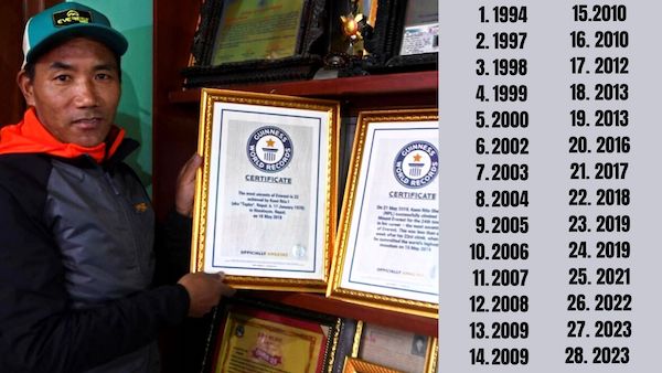
Remarkably, around 600 people successfully reached the pinnacle of the world, among them 350 Sherpas providing support to 250 clients. Among the summiters, impressive records were set, including Kami Rita Sherpa achieving an astonishing twenty-eighth Everest summit.
However, this success came at a cost, as the unfortunate news confirmed the loss of 13 climbers and Sherpas, with an additional 4 individuals still missing and presumed deceased. This season witnessed the highest death toll in a single season on Everest.
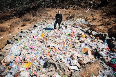
Regrettably, traditional mountaineering norms, which have long governed etiquette on the mountain, were disregarded, evident from the piles of trash on Everest and reports of theft at the base camp.
So, Which Climbing Route is Safer on Everest?
Determining the safest climbing route on Everest is a complex matter, as each route presents its own set of challenges and risks. The choice of route often depends on an individual’s climbing experience, fitness level, and the level of support they seek from guiding companies.
Historically, the standard routes like the Southeast Ridge from Nepal and the North Ridge from Tibet have seen more summits and thus may appear to be safer due to well-established infrastructure and experienced guides.
However, it’s essential to remember that any ascent on Everest carries inherent risks, and factors like weather, avalanche-prone areas, and changing conditions can significantly impact safety. Climbers must prioritize thorough preparation, sound decision-making, and adherence to responsible mountaineering practices to ensure a safe and successful climb, regardless of the chosen route.
FAQs: Climbing Routes on Everest
Below are the most frequently asked question about climbing routes on Everest:
Mount Everest has approximately 20 identified climbing routes, each offering its unique challenges and allure. The mountain features three prominent faces: the Southwest Face from Nepal, the East Face (Kangshung Face) from Tibet, and the North Face, also from Tibet. Among these, the Kangshung Face stands as the least attempted and summited, shrouding it in an air of mystery and adventure.
The South Col Route stands as the favored path to the pinnacle of Mount Everest, commencing from the Nepalese side of the mountain. Renowned for its relative ease, this route is widely regarded as the most accessible path to reach the summit.
Most challenges on Mount Everest have been conquered, except for two exceptionally difficult routes: a direct climb up the avalanche-prone East Face and an ascent of the North Pillar on the East Face, known as the “Fantasy Ridge.”
Mount Everest offers more than 20 named routes, with a few still unclimbed. However, the overwhelming majority of climbers opt for the South Col or the Northeast Ridge Standard (North Col) routes.