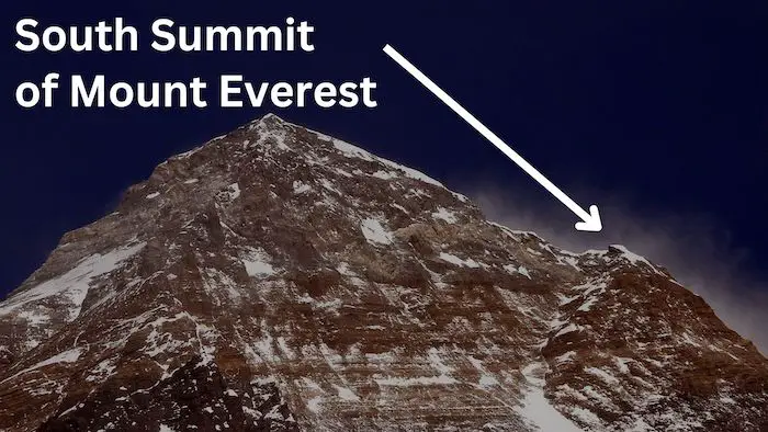
The South Summit of Mount Everest serves as a subsidiary peak to the main apex of Everest’s mountain mass. Despite the South Summit’s altitude of 8,749 meters (28,704 feet) above sea level, which surpasses the elevation of Earth’s second-highest mountain, K2, at 8,611 meters (28,251 feet), it is not classified as an independent mountain. Due to its modest prominence of just 11 meters and proximity to the main peak. The primary peak of Mount Everest reaches an elevation of 8,849 meters (29,032 feet) above sea level.
Location and Features of the South Summit of Mount Everest:
The peak of the South Summit takes the form of a snow and ice-covered dome. It is linked to Mount Everest’s summit through the Cornice Traverse and the Hillary Step. It is positioned around 130 meters (430 feet) away from the higher main apex of the mountain. During the 1953 British Mount Everest expedition Charles Evans and Tom Bourdillon became the first to conquer this lower peak. Their accomplishment took place at 1 pm.
However, due to difficulties with Evans’ oxygen equipment, they couldn’t proceed to the primary summit. Three days later, on May 29, Edmund Hillary and Tenzing Norgay passed the southern peak to successfully reach the main summit.
What is the South Summit of Everest?

The South Summit of Everest is a prominent point along the route to the main summit of Mount Everest. It is not considered a separate mountain peak but rather a subsidiary peak and significant topographical feature on the path to the true summit of Everest. The South Summit is located at an elevation of approximately 8,749 meters (28,704 feet). About 100 meters lower than the true apex.
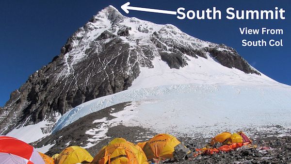
Climbers ascending the standard Southeast Ridge route to reach the summit of Everest encounter the South Summit along the way. The route from the South Col involves negotiating challenging sections such as the Cornice Traverse and the Hillary Step before reaching the highest point on the mountain.
The South Summit offers climbers breathtaking views and is often used as a stopping point for rest and equipment adjustments. It also holds historical significance in mountaineering. Particularly due to its association with the British Mount Everest expedition of 1953. When climbers Charles Evans and Tom Bourdillon reached this point, and later, Edmund Hillary and Tenzing Norgay went on to successfully summit the main peak.
Despite not being a separate mountain, the South Summit is a vital landmark in the journey to conquer Mount Everest. Moreover, it is frequently mentioned in mountaineering accounts and expedition reports, in which cite the significant milestone.
How High is The South Summit Of Everest?
The South Summit of Everest’s height is 8,749 meters (28,704 feet). Which surpasses the elevation of Earth’s second-highest peak: K2, which stands at 8,611 meters (28,251 feet). However, it doesn’t hold the status of an independent mountain due to its minimal prominence of merely 11 meters and association with the main summit of Everest.
History of Everest’s South Summit Events:
Upon reaching the South Col in 1953, expedition leader John Hunt was awestruck by the scene. He penned,
“Above us, the South Summit of Everest soared—a graceful snow pinnacle, astonishingly near yet almost 3,000 feet above our heads… none of us had anticipated a sight so striking, so exquisitely beautiful. It felt as though an unanticipated peak of alpine grandeur had emerged above the South Col.”
John Hunt during 1953 Everest Expedition
During a 1965 Indian Everest expedition, Chandra Prakash Vohra made a remarkable discovery: fossilized seashells within limestone. He found them approximately 100 feet above the South Summit, which he was thrilled about as a geologist.
Reflecting on his oxygen-less ascent of Mount Everest in 1978, Reinhold Messner labeled the South Summit as a “significant milestone for me.”
Tragedy struck the South Summit during the 1996 Mount Everest disaster. Mountain guide Rob Hall and three others lost their lives while descending from the main summit in a blizzard. Hall managed to survive the night and establish radio contact the following day, only to succumb to the cold on May 11, 1996. His body remains atop the South Summit.
The South Summit has become a common stopover for climbers for a variety of purposes, including potential turnarounds. In clear weather, this vantage point offers views of the cornice traverse, Hillary Step, and the summit itself. For contemporary climbers using supplemental oxygen, it serves as a preferred location for changing oxygen bottles.
When Was The First Ascent of the South Summit on Everest?
The first ascent of the South Summit of Everest was achieved by Charles Evans and Tom Bourdillon as part of the 1953 British Mount Everest expedition. They reached the South Summit on May 26, 1953.
However, they were unable to proceed to the primary summit due to issues with Evans’ oxygen equipment. The main summit of Everest was successfully reached by Edmund Hillary and Tenzing Norgay on May 29, 1953, just a few days later.
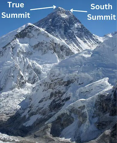
South Summit Everest Map:
Below is a map of the South Summit of Mt Everest, and the true summit. They are in close proximity to each other, and according to Google Maps are less than 300 meters apart (straight line). However, the elevation change between the two is approximately 130 meters.
Below are images and maps showing the South Summit of Mount Everest.