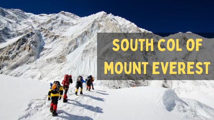
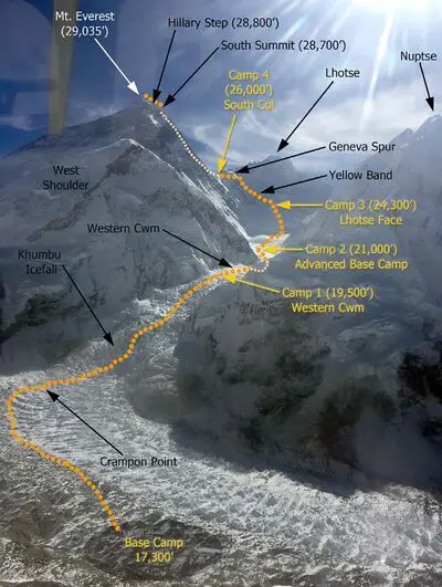
There are two primary climbing routes of Everest, i.e. the South Col and the Northeast Ridge. The South Col stands as a distinct, narrow pass nestled between Mount Everest and Lhotse, the first and fourth highest peaks on Earth.
Following the closure of Tibet in 1950, the majority of Everest expeditions have departed from Nepal. Taking the route via the southeast ridge and the South Col, rather than the North Col. Climbers embarking on an Everest ascent from Nepal’s southeast ridge typically establish their final camp (usually Camp IV) at the South Col.
South Col Conquests: Early Expeditions to Mount Everest
On May 12, 1952, the South Col was successfully reached by Aubert, Lambert, and Flory as part of Edouard Wyss-Dunant’s Swiss Mount Everest Expedition. Unfortunately, their attempt to reach the summit was unsuccessful. The next year, during the historic first ascent of Mount Everest, Wilfrid Noyce and the Sherpa Annullu were the first members of the expedition to reach the col. According to expedition leader John Hunt:
It was 2.40 p.m. Wilfrid Noyce and his companion Annullu stood at that moment above the South Col of Everest, at about 26,000 feet [7,900 m]. They were gazing down on the scene of the Swiss drama, and they were also looking upwards to the final pyramid of Everest itself. It was a great moment for them both, and it was shared by all of us who watched it. Their presence there was symbolic of our success in overcoming the most crucial problem of the whole climb; they had reached an objective which we had been striving to attain for twelve anxious days.
– John Hunt
Mount Everest’s Dominant Route: The South Col
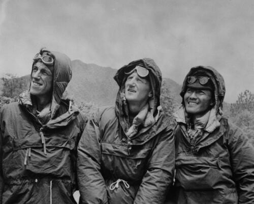
The South Col route, pioneered by John Hunt’s expedition, follows the Southeast Ridge-South Col path. It was on this route that Sherpa Tenzing Norgay and New Zealander Edmund Hillary achieved the historic feat. They became the first individuals to summit Mount Everest as part of the British expedition in 1953.
Before their successful ascent, the South Col route had only been attempted twice by Swiss teams, once in the spring and autumn of 1952. Over the years, this route has gained popularity, and today, hundreds of climbers from all corners of the world attempt to stand on Everest via this challenging path.
The South Col route is considered slightly more dangerous, primarily due to the inherent instability of the Khumbu Icefall. However, some mountaineers perceive it as somewhat easier than the North Ridge route because it lacks the need for ladders and rock climbing on steep sections.
Quick Facts: Elevation and Timestamps
- Base Camp: 17,500’/5334m
- Khumbu Icefall to Camp 1 (C1): 19,500’/5943m – 3-6 hours, 1.62 miles
- C2: 21,000’/6400m – 2-3 hours, 1.74 miles
- C3:23,500’/7162m – 3-7 hours, 1.64 miles
- Yellow Band – 1-3 hours
- Geneva Spur – 1-2 hours
- South Col: 26,300’/8016m – 1 hour or less
- Balcony: 3 – 6 hours
- South Summit : 28500′ – 8690m – 3 to 5 hours
- Hillary Step – 1 hour or less
- Summit: 29,035′ / 8850m – 1 hour or less
- Return to South Col: 3 -7 hours
- Return to C2: 3 hours
- Return to Base Camp: 4 hours
Detailed South Col Route Descriptions
Below is a typical climbing schedule for the south side of Mount Everest, outlining the average time and distance for each section, along with a detailed description.
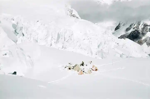
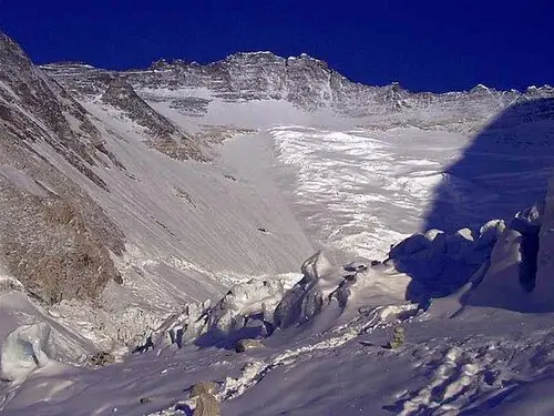
Situated on a moving glacier, tents can shift and platforms may melt. Despite the harshness of the environment, the area boasts a captivating beauty, surrounded by the presence of Pumori and the Khumbu Icefall. Amidst numerous expedition tents, intersecting pathways, and the sound of generators, the place offers an ambiance of a small, vibrant village.
1. Khumbu Icefall to Camp 1
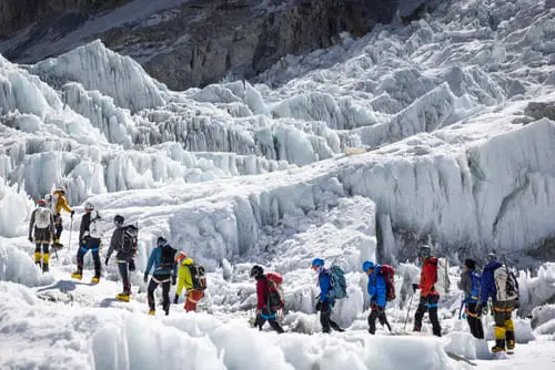
The Khumbu Icefall is a 2,000-foot ascent on a constantly shifting glacier, featuring deep crevasses and towering seracs. Climbers set out before sunrise to avoid the glacier heating up later in the day. They start around 3:00 AM after a quick breakfast and prepare for the climb ahead.
The icefall’s terrain varies from steep 60-degree climbs to gentler 20-degree slopes, often requiring climbers to cross long ladders. Breathing is labored due to the altitude, and climbers use Buffs to warm their breath and manage their cough.
As they ascend, they must be cautious of potential avalanches and seracs that threaten to fall. The section known as the Popcorn is particularly prone to these dangers. After a few hours, climbers reach the football field, a flat snow area where they can take a break. From there, they proceed to the Upper Icefall, where they might be misled by false summits thinking that the Khumbu Icefall is closer. However, they don’t realize that there is much further to climb. This final section involves steeper ladders and sharper grades.
At the top of the icefall, the terrain levels out, leading into the Western Cwm. Camp 1 is still ahead, about half to a full hour’s journey from there. As climbers acclimatize, they become more adept, but the Khumbu Icefall remains a challenging and ever-changing part of their ascent.
2. Western Cwm: A Hot and Crevassed Path to Camp 2
The Western Cwm presents challenges with its heavily crevassed terrain, prompting teams to stay roped up or clipped into fixed ropes. The 2-3 hour walk (1.74 miles one way) from Camp 1 to Camp 2 can be scorching, with temperatures in Everest easily reaching 100 degrees Fahrenheit.
As climbers traverse the Cwm, they struggle with hazards such as hidden crevasses under thin snow bridges. Camp 2, situated on the Eastern end of Cwm, serves as Advanced Base Camp. It is also a starting point for the summit.
Camp 2 lies about 1.74 miles away from Camp 1, with an altitude gain of 1,500 feet. Although not far or high, the journey can be challenging due to the scorching heat, encouraging climbers to depart early in the morning.
The last half-hour can be mentally demanding as the route steepens, leading to Camp 2 proper, where tents are arranged along a rising rock gully. If the camp is at the gully’s top, the final half-hour can be quite grueling.
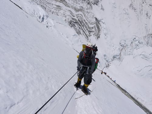
3. Lhotse Face: A Challenging Ascent to Camp 3
The Lhotse Face, an impressive steep wall of hard-packed ice and snow, houses Camp 3 on the fourth-highest peak in the world, Lhotse, standing at 27,920 feet. Climbers go up this face twice during their summit attempt, first for acclimatization and then en route to the top.
The Lhotse Face presents considerable risks, with climbers facing the challenging task of gaining a grip with their crampons on the steep angle and hard ice. To ensure safety, they must remain clipped into the fixed line at all times, even while at Camp 3. Two ropes, one for ascending and one for descending, are anchored to the face with ice screws. Climbers need to navigate junctions, unclipping their carabiners and jumars in a two-step process to stay attached to the fixed line.
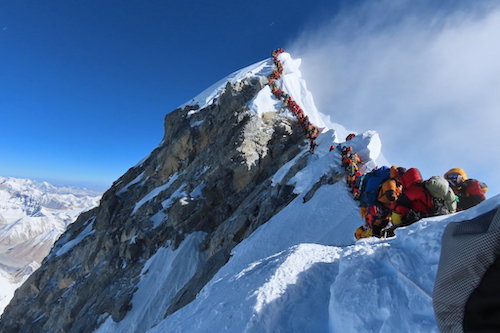
The Lhotse Face can get crowded, with long lines of climbers going up and others coming down. It is often with Sherpas returning from carrying loads to higher camps, lead to an unexpected “traffic jam” in the middle of the Himalayas.
The steepness of the angle, particularly near the bergschrund at the base and close to the uppermost camps, can be incredibly tiring. Each step involves kicking crampon points into the ice. Despite the well-trodden path formed by thousands of kicks, a storm can erase progress, requiring climbers to start anew.
Due to the scarcity of flat areas, there are usually two or three levels of camps on the Lhotse Face, with Sherpas carving out tent platforms. The final approach into Camp 3 can be tiring for most climbers, as they battle exhaustion, dehydration, and steep terrain. However, the breathtaking views from the tent make the effort worthwhile on clear days.
4. Camp 3 to South Col: Yellow Band and the Geneva Spur
Climbers on their way to the summit must pass the Yellow Band and the Geneva Spur (25,000 feet). The South Col, an unforgiving world, offers only a brief stay due to its harsh weather and destructive altitude. The time taken to reach South Col varies from 8 to 12 hours, depending on the climb from Camp 3.
Starting from Camp 3, the terrain is steep, and most climbers rely on supplemental oxygen. After a few hours, they come across the Yellow Band, a limestone strip that cuts through the Himalayas. It requires focused effort to climb the smooth rocks at a 20 to 30-degree angle. Fixed ropes prove invaluable here. Traffic jams can occur when multiple teams aim for the summit on the same day.
Beyond the Yellow Band, the path somewhat flattens until they reach the bottom of the Geneva Spur, a 150-foot stretch of 40-degree rock, ice, and snow. Though daunting, it is manageable due to well-trodden steps and uneven rock that allows for secure footing.
Climbers follow a rocky path worn by previous ascents, reaching the South Col proper – an expansive area with clustered tents. However, most are captivated by their first view of Mount Everest’s summit pyramid, which stands as a surreal moment before they continue their quest to the top.
5. Summit Bid: South Col to Balcony and Rest
The summit bid commences before midnight, with a steep climb up the South side of Everest. Once reaching the Balcony at 27,500 feet, climbers head west up the ridge to the South Summit, then pass over the Hillary Step onto the Summit Ridge, finally arriving at the summit.
In favorable weather, with calm winds and temperatures around zero, the experience is comfortable in down suits. Sherpas on Everest double-check the crampons’ tightness, harnesses’ proper fastening, and the oxygen’s correct setting with the regulators.
The climb from the South Col features some of the steepest and most sustained sections of the South Col route, until reaching the slabs. In low snow years, the movement of crampons on rock can lead to slips, sapping energy. On good snow years, a well-worn path usually develops on the route, aiding progress.
Climbing through the Triangular Face to the Balcony feels long and chilly in the dark. A partial moon often illuminates the surrounding ground and nearby mountains, such as Makalu and Lhotse. Although the route may seem endless, the sight of headlamps standing still ahead indicates the arrival at the Balcony or the flat area below it. Here, climbers typically change oxygen bottles for fresh ones, taking the opportunity for a well-deserved food and water break.
6. Challenges on the Climb from Balcony to South Summit
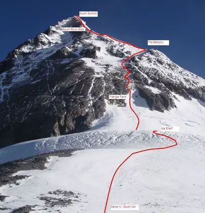
The ascent from the Balcony to the South Summit can prove longer and more difficult than expected, greatly influenced by snow conditions. In low snow years, navigating smooth rock slabs just below the South Summit can be tricky with crampons, while in high snow years, dealing with deep snow drifts becomes problematic. The final stretch to the South Summit can be notably steep.
Climbers begin the section with a somewhat gentle grade, which quickly escalates to 30 degrees on a snow-packed boot path, especially during busy climbing seasons. However, things change as they encounter the slabs, a lengthy stretch of smooth to jumbled rock, spanning about 200 feet. The difficulty of the slabs varies from mildly annoying to extremely steep and hard. Some parts feature 20 to 30 feet high “cliff-like” sections with 60-degree angles, where climbers rely on their crampon front points and jumars to pull themselves up, leading to exhaustion. This section often creates bottlenecks for climbers ascending and descending.
Beyond the slabs, the slope becomes even steeper, reaching around 60 degrees, which can be hard to fathom in the moment. However, this section is relatively short, approximately 100 feet, and on a wide snow slope. Upon reaching the South Summit, climbers gain a clear view of the final route to the true summit, sparking a sense of nearing the summit. The steepness and the significant elevation gain still to come might come as a surprise.
After ascending the South Summit, climbers must descend about 50 feet before encountering a small rock climb, sometimes mistaken for the Hillary Step. The following challenge is the Cornice-Traverse, a knife-edge ridge leading to the Hillary Step. This section poses the most exposure on the Southeast Ridge climb, with an 8,000-foot drop on one side and an 11,000-foot drop on the other. Some climbers may experience vertigo and uneasiness due to the soft edges on the boot tracks. At the top of the Hillary Step, a large boulder (chockstone) sitting on a ledge obstructs the route.
7. The Summit Journey: The Final Leg and Return Challenges
The last section holds unexpected surprises for most climbers. Instead of a long snow slope with the summit in clear sight, they encounter small hills and bumps. It blocks the view and demand further physical effort, on top of the altitude challenges. It takes about 20-30 minutes from the Hillary Step to catch the first glimpse of the summit, marked by prayer flags.
The summit itself is not large, measuring around 30 square feet. A small bench is carved out of the snow for climbers to pose for pictures. On one side, they can see the route from the north side, Tibet. However, climbers must be cautious during the return climb, as it can be dangerous and has the highest accident rate. Fatigue, weather conditions, and climbers letting their guard down contribute to the risks. The descent typically takes a little over 3-4 hours to reach the South Col.
Challenges and Surviving the South Col:
Climbers who reach the South Col find themselves in the death zone of Everest, where altitude sickness poses a significant and potentially fatal threat. The extreme elevation makes sleep difficult, and most climbers experience a significant slowdown or complete cessation of their digestive systems. At this height, the body becomes more efficient in using stored energy rather than processing new food.
To cope with the harsh conditions, most climbers resort to supplemental oxygen, but they only have a narrow window of two or three days to attempt the summit. The success of their ascent hinges on favorable weather conditions with clear skies and low winds. If the weather does not cooperate within this short timeframe, climbers are compelled to descend, often all the way back to Base Camp.
Due to the high stakes and limited opportunities, climbers rarely get a second chance to return to the South Col during a specific expedition. The South Col presents a formidable challenge, demanding resilience and strategic planning to conquer its heights.
Record-Breaking Landings and High-Altitude Weather on South Col of Mount Everest
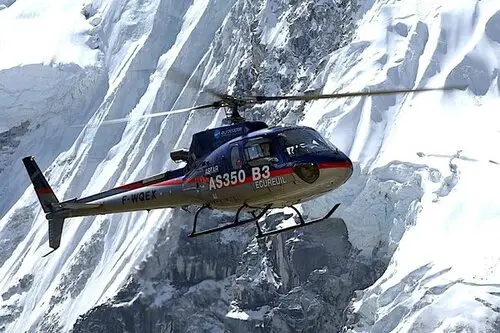
In 2005, Didier Delsalle from France landed a Eurocopter AS350 B3 helicopter on the South Col of Mount Everest. Just two days later, he accomplished another groundbreaking milestone. He also was the first to land a helicopter landing on the summit.
In May 2019, the world’s highest weather station was installed on Everest. With one location positioned at the South Col and another higher up on the peak, known as “The Balcony,” along with additional stations in various spots. These weather stations are about 7 feet (2.1 m) tall and weigh 110 pounds (50 kg). They provide crucial data on the mountain’s extreme weather conditions. Notably, on 21 July 2022, a record-breaking maximum temperature of −1.4 °C (29.5 °F) was registered at the South Col.
FAQs: South Col of Mount Everest
Below are the most frequently asked questions about South Col of Mount Everest:
The high camp, commonly known as Camp IV, sits on a rocky and wind-swept saddle between Everest and Lhotse. The term “Col” originates from the Welsh language, referring to a saddle or pass. The British Reconnaissance Expedition of 1921 gave this location its name as they viewed it from a vantage point about 7 miles away.
The South Col, a different World at 26,300 feet, it’s the launching point for the summit bid. Due to the harsh weather and high altitude’s toll, climbers don’t spend time here for long. Typically, the stay lasts 8 to 12 hours, depending on the climb from Camp 3.
The majority of mountaineering challenges on Mount Everest have been conquered, except for two routes with extraordinary difficulties. A direct and unclimbed path up the avalanche-prone East Face, and the ascent of the north pillar on the East Face, also known as the “Fantasy Ridge,” as described by George Mallory.
Upon reaching the South Col, climbers enter the death zone, where altitude sickness poses a substantial and potentially fatal threat.