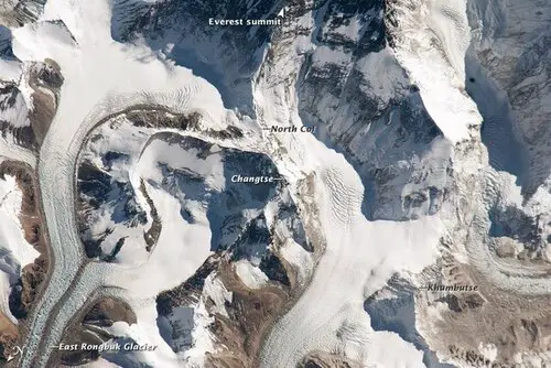
The North Col or North East Ridge climbing route on Everest signifies the razor-sharp mountain pass sculpted by glaciers. It is along the ridge that connects Mount Everest and Changtse in the Tibetan region. This pass constitutes the uppermost part of the East Rongbuk Glacier.
When mountaineers ascend Everest via the North ridge in Tibet, they establish their initial camp on the mountain itself, traditionally known as Camp IV. But now it is referred to as modern Camp I, situated on the North Col. Starting from this point, which sits at around 7,020 meters (23,030 feet) above sea level, climbers progress up the North Ridge, setting up a series of increasingly elevated camps along the North Face of Everest. The ultimate push to reach the summit occurs from Camp VI, positioned at an altitude of 8,230 meters (27,001 feet).
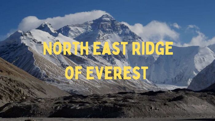
Early Expeditions to Mount Everest via The North East Ridge
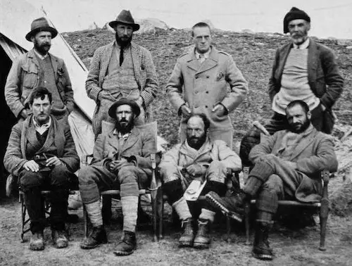
The northern face of Mount Everest holds a rich historical legacy, marked by numerous endeavors during the 1920s and 1930s. The inaugural venture started by a British Reconnaissance Expedition in 1921. Guided by George Mallory, a small team aimed to be the first to step on the mountain’s soil. They ascended to the North Col at 7,003 meters.
Subsequently, the 1922 British expedition reached an altitude of 27,300 feet before retracing their steps. It made them the pioneer team to use supplementary oxygen. Regrettably, this mission also bore witness to the mountain’s first casualties, with an avalanche claiming the lives of seven Sherpas on Everest.
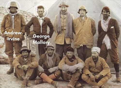
In 1924, another British expedition, led by George Mallory and Andrew Sandy Irvine, is best remembered for the enigma surrounding their potential summit. If proven, their conquest would predate Tenzing Norgay and Sir Edmund Hillary’s achievement by nearly three decades. The discovery of Mallory’s remains in 1999 raised questions about the circumstances of his demise. Whether it occurred during the ascent or descent.
Thus, the quest to locate the camera with possible summit photographs became paramount. Over the years, efforts have been made in this pursuit. In 1933, Irvine’s wooden ice axe was recovered along the trajectory of the climbers’ final known path. In 1960, a Chinese porter reported an encounter with an “English dead body,” though no visual evidence was captured.
Summit Triumphs and Challenges: Mount Everest’s Tibet-Side Expeditions
The inaugural Tibet-side summit was accomplished by a Chinese Everest expedition on May 25, 1960. The achievement was attributed to Nawang Gombu, a Tibetan climber, and the Chinese duo of Chu Yin-Hau and Wang Fu-zhou.
An intriguing anecdote states that Wang Fu-zhou scaled the challenging Second Step of the ascent using only his sock-clad feet. However, due to the absence of a photograph taken at the summit, skepticism shrouded the veracity of their accomplishment. In 1975, the Chinese claim was substantiated as they successfully reached the summit, coinciding with the installation of a ladder on the formidable Second Step.
From 1950 to 1980, Tibet remained inaccessible to foreign nationals, effectively halting any subsequent endeavors. It wasn’t until 1980 that a Japanese expedition achieved a summit through the Hornbein Couloir on the North Face, marking the first successful ascent following this prolonged closure.
Quick Facts: Elevation and Timestamps
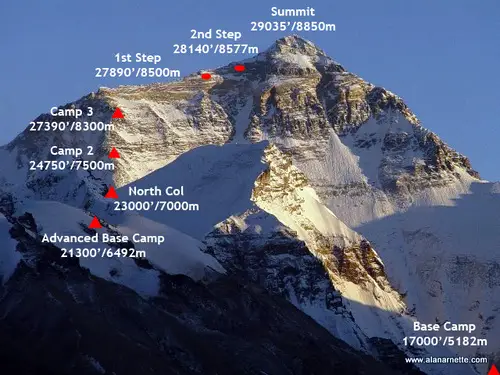
- Base Camp: 17000 feet/ 5182m
- Interim Camp: 20300 feet/ 6187m – 5 to 6 hours (first time)
- Advanced base camp: 21300 feet/ 6492m – 6 hours (first time)
- North Col or C1: 23,000 feet/ 7000m – 4 to 6 hours (first time)
- Camp 2: 24,750 feet/ 7500m – 5 hours
- Camp 3: 27,390 feet/ 8300m – 4 to 6 hours
- Yellow Band
- First Step: 27890 feet/ 8500m
- Mushroom Rock -28047 feet/ 8549m – 2 hours from C3
- Second Step: 28140 feet/ 8577m – 1 hour or less
- Third Step: 28500 feet/ 8690m – 1 to 2 hours
- Summit Pyramid: 2 hours
- Summit: 29,035 feet/ 8850m – 1 hour
- Return to Camp 3: 7 -8 hours
- Return to ABC: 3 hours
Detailed North East Ridge Route Descriptions
Below is a typical climbing schedule for the north side of Mount Everest. It outlines the average time and distance for each section, along with a detailed description.
1. Base Camp to Advanced Base Camp (ABC, 6400m)
From Base Camp to Advanced Base Camp (ABC), a distance of approximately 12 miles (22km). The journey involves traversing challenging terrain composed of boulders, ice, and snow. The pathway traces the course of the Rongbuk Glacier until its confluence with the Eastern Rongbuk Glacier. ABC is situated on the northeastern side of the East Rongbuk Glacier, beneath the slopes of Changtse Mountain.
For the initial trip to ABC, individuals typically undertake a two-day hike, with a stopover at an intermediate camp. After becoming acclimatized to the altitude, the trek can be accomplished in a single day. Serving as the primary High Camp for climbers on the Northeast Ridge expedition, ABC plays a crucial role. Climbers utilize the lower base camp for rest and preparation before embarking on their determined ascent towards the summit.
2. ABC to North Col (Camp I)
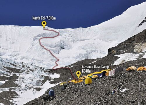
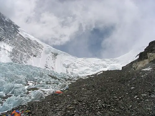
Ascending from ABC, the North Col camp presents a climb of 2,200 feet. As climbers depart from Camp 1, they arrive at the East Rongbuk Glacier, where they wear their crampons for the first time. After a brief stroll, the mountaineers secure themselves to the fixed rope.
The journey from ABC to the North Col showcases a gradual elevation gain, marked by a steep segment with an incline of 60 degrees, creating a near-vertical experience. Climbers remain harnessed to the fixed rope, employing their ascenders to facilitate the ascent. The descent of this portion is managed through rappelling techniques, and in certain instances, ladders are positioned over deep crevasses.
The duration required to reach the North Col varies between 4 to 7 hours, contingent on the extent of acclimatization and prevailing weather conditions.
3. Camp 1 to Camp 2
Initiating the phase of “High Camps,” C2 comes into view. The pathway predominantly consists of pristine snow, although instances of rocky terrain can arise due to the region’s susceptibility to strong winds.
The estimated time to traverse to C2 ranges from 3 to 5 hours. Certain expedition teams opt to utilize this location as their uppermost camp, strategically employing it to facilitate the process of acclimatization.
4. Camp 2 to Camp 3
Certain expeditions forgo the utilization of Camp 3 and instead proceed directly to the altitude of 8,300 meters. Beyond the 7,900-meter mark, a significant number of climbers opt to rest while using supplemental oxygen.
The ascent is characterized by highly turbulent winds, necessitating the placement of tents on narrow rock ledges, as sizeable and flat areas are scarce. The positioning of Camp 3 benefits from the shielding effect of Everest’s North Face, which helps alleviate the impact of the wind and renders sleeping more manageable. Climbers allocate a time frame of 3 to 6 hours to attain Camp 3.
In terms of elevation and exposure to the elements, this point equates to the South Col on the opposing side of the mountain.
5. Camp 3 to Camp 4
Camp 4 (or Camp 3 in cases where the preceding camp is bypassed) emerges as a brief interlude for the majority of climbers en route to the summit. Situated at an altitude of 27,390 feet, it’s advisable not to linger extensively at this point. Climbers make a quick stop to replenish their sustenance and hydrate, possibly catching a brief nap, before embarking on their ascent towards the summit, often commencing around 10:00 PM.
Upon departing from the third camp, climbers proceed along the established fixed rope, navigating through a gully filled with snow which constitutes a segment of the Yellow Band. Subsequently, climbers transition onto a slight ramp, leading them to the proper expanse of the northeast ridge.
The Northeast Ridge lies a few hundred feet above the altitude of Camp 4, positioning climbers for their continued ascent.
6. Camp 4 to Second Step
The Northeast Ridge constitutes the most demanding section of climbing along this route, characterized by three distinct “steps” or rock climbs along its course.
The initial step, known as the 1st Step, introduces a challenging rock feature at this high altitude. The established route generally veers to the right of the summit pinnacle. A subset of climbers might describe this section as steep and arduous, necessitating forceful exertion on the fixed ropes within the final gully leading to the ridge.
The presence of Mushroom Rock, a prominent landmark on the Ridge, serves as a gauge for both spotters and climbers to gauge their progress during the ascent on summit night. This point also serves as an oxygen swapping location. The path may be strewn with loose rocks, adding an additional layer of complexity to negotiating the terrain while wearing crampons.
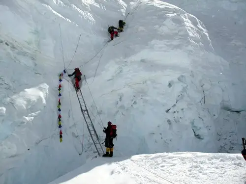
The 2nd step presents the crux of the climb, featuring the Chinese Ladder. Climbers must initially ascend approximately 10 feet of rock slab before confronting a nearly vertical 30-foot ladder. This segment is particularly exposed, with a sheer vertical drop spanning 10,000 feet.
The descent of this portion is notably more challenging, as visibility of one’s foothold placement on the ladder rungs is limited. Notoriously, this brief passage is associated with prolonged delays, subsequently increasing the susceptibility to frostbite or Acute Mountain Sickness (AMS).
7. Third Step to Summit
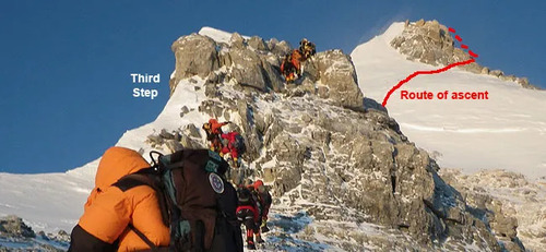
The third step involves going up a straightforward rocky path. But at this high altitude, it’s not easy due to the difficulties that come with being so high up. Subsequently, climbers allocate the following hour to navigate the snowfields encompassing the Summit Pyramid.
This particular stretch is characterized by a steep snow slope, often plagued by gusty winds and extreme cold, thereby leaving climbers in a profoundly exposed state. As they progress towards the upper reaches of the Pyramid, climbers once again face significant exposure while circumnavigating a sizable outcropping. Here, they also encounter three additional small rock steps positioned along a ramp before embarking on the ultimate ridge ascent leading to the summit.
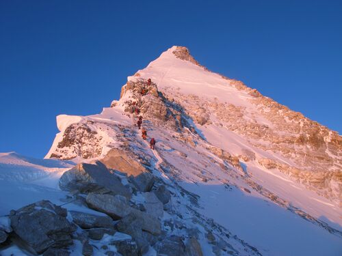
The Summit Ridge emerges as the final stretch, spanning a horizontal distance of 500 feet along the ridge towards the summit. This segment remains notably exposed, with slope angles varying between 30 to 60 degrees. The ridge is narrow, with vertiginous 10,000-foot precipices on both sides that directly lead to the pinnacle of Everest.
At this juncture, climbers will have expended 8 to 10 hours to reach the summit. The subsequent journey back to Camp 3 requires an additional 4 to 6 hours of effort.
Conquering Mount Everest’s North East Ridge Challenges
Unlike the South Col Route, the North East Ridge route unfolds through a series of steps, each demanding both physical and mental fortitude. From the initial Camp 4 or 3, climbers embark on an arduous journey, transcending steep rock features and snowfields.
Ultimately, the Northeast Ridge route on Mount Everest is a poignant reminder of human tenacity that drives individuals to conquer the world’s highest peaks. Each step, each ascent, and each challenge overcome exemplifies the dedication and courage required to scale the pinnacle of human achievement, as climbers etch their names in the history of Everest’s conquest.