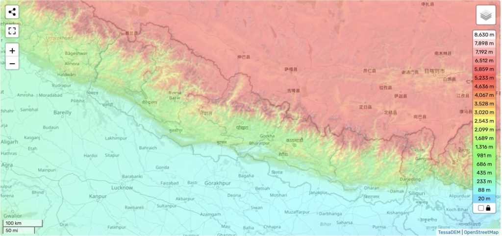
Nepal’s topography is vast and ranges significantly. With the highest altitude being 8,849 meters (29,032 feet), and the lowest being Kechana Kalan in Jhapa (60 m). These vast differences in altitude, means Nepal has the greatest change in elevation of any country in the world.
For many travelers coming to Nepal, the high elevations can be a point of excitement as well as fear. With tourists not being used to the elevations, thoughts of high altitude sickness can creep into thought. I know before I came to Nepal, I was worried about the elevation change since I was coming from Salem Oregon with an elevation of 47 meters!
Tourists are often so baffled by the height and elevation in Nepal, that we call the hills around the Kathmandu Valley mountains!
To help prepare travelers for the trip in Nepal, I will go over the elevation of some of the most important cities and places in Nepal.
Let’s start by looking at the average elevation of Nepal.
What is the elevation of Nepal?
Nepal has three distinct topographical regions with different elevations. The mountains range from 4,800 meters to 8,839 meters above sea level. The Hill region from 610 meters to 4,800 meters above sea level, and the Terai or low lands from 610 meters to 60 meters.
What is Nepal’s Average Elevation?
Nepal has an average elevation of 3,265 meters above sea level. The highest point in Nepal is Mount Everest at 29,031.69 feet (8,848.86 meters), and the lowest is in Jhapa at 196.85 feet (60 meters). This average altitude makes Nepal one of the highest countries in the world!
The difference in elevations throughout the country makes it difficult to navigate at times. Moreover, it means that you may be traveling on some of the most dangerous highways in the world.
What is the height of Kathmandu Valley from sea level?
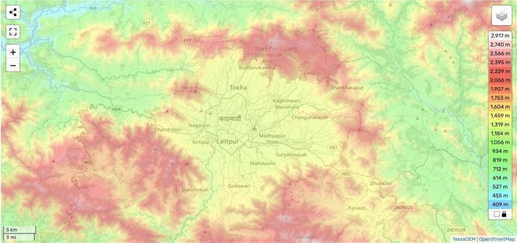
The height of the Kathmandu Valley from sea level is 1,400 meters. The height of the KTM valley ranges between 1,280 meters and 2,300 meters.
Along the outskirts of the Kathmandu Valley in the surrounding hills, elevations reach much higher, including Shivapuri (2,800m), Phulchowki (2,795m), Nagarjun (2,825m), and Chandragiri (2,551m).
The Kathmandu Valley currently has one of two international airports in the country, meaning that almost all tourists will first arrive at Tribhuvan International Airport before departing on their vacation in Nepal. With most travelers spending at least a few days in the ancient city of Kathmandu, it is important to note that there are three districts in the Kathmandu Valley. All with different elevations.
What is the altitude of Kathmandu?
Kathmandu has an altitude between 1,280 meters and 1,340 meters (4,200 ft and 4,396 ft). The city lies in the lowest elevations of the Kathmandu Valley.
What is the elevation of Lalitpur?
The elevation of Lalitpur ranges from 1,324 meters (4,344 ft) in Patan, to a max elevation of 2,300 meters (7,546 ft) in the southern part of the district.
What is the elevation of Bhaktapur?
Bhaktapur has an average elevation of about 1,401 meters (4,596 ft). As it is the smallest district in all of Nepal, the elevation of the city does not fluctuate significantly.
Other Important Elevations in the Kathmandu Valley:
With the Kathmandu Valley comprising three distinct districts, and covering an area of 933.73 square kilometers, the elevations of the region differ significantly. Therefore, to offer a complete picture, I want to include some additional points of elevation in the area besides the three cities.
- Shivapuri at 2,800 meters
- Phulchowki at 2,795 meters
- Nagarjun at 2,825 meters
- Chandragiri at 2,551 meters
Elevation of Pokhara:
The altitude of Pokhara varies from 827 meters (2,713 feet) in the southern portion of the city to about 1,740 meters (5,710 feet) in the northern parts of the city.
In the south where elevation is lower, the city runs into Phewa Tal (commonly known as Lakeside) at an elevation of about 827 meters (2,713 feet). For the maximum elevation of Pokhara, Lumle can be found in the north portion of the city at 1,740 meters (5,710 feet) which touches the base of the Annapurna range.
Moreover, as the ground is extremely porous in the Pokhara valley, there are also underground caves which extend further down in elevation. An example would be the Mahendra Gufa, the Chamere Gufa (Bat cave) and Gupteshwor Cave.
Want to know more about Pokhara? Then make sure to check out my Pokhara travel guide!
What is the elevation of Chitwan?
Chitwan’s height above sea level ranges from 100 m (330 ft) in the Narayani-Rapti river valleys and to a maximum height of 815 m (2,674 ft) in the Sivalik Hills to the north of Chitwan.
Chitwan can be found in the southern plains (terai) of Nepal, close to the Indian border. Chitwan is mostly flat with lower elevations because of its geographic location. However, as the district extends towards the north, it runs into the hilly region, giving rise to its higher elevations in the Sivalik Hills.
Want to learn more about Chitwan? Then check out my Chitwan Travel Guide!
What is the elevation of Mount Everest?
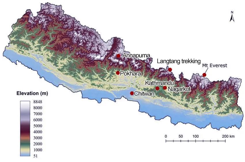
The elevation of Mount Everest is 29,031.69 feet (8,848.86 meters) above sea level. In other words, Everest is almost 5.5 miles (8.8 kilometers) tall!
Mount Everest is the highest point in Nepal, as well as the entire world. The tallest mountain in the Himalayan range, Everest can be found on the border of China (Formerly Tibet) and Nepal. Moreover, on Everest itself, there is a region that is called the ‘death zone’. Where climbers stop to rest every few thousand feet. When they reach 26,247 feet (8,000 meters), they’ve entered the death zone.
With such great elevations there is a significant risk of high altitude sickness. It is important for trekkers taking on the mountain, or even Everest Base Camp sitting at 17,598 feet (5,364m). Although Everest is impressive in itself, Nepal has eight Peaks Over 8000 M. To see the full list of mountains in Nepal and their elevations, make sure to check out my blog of tallest mountains in Nepal!
Elevation of important cities in Nepal:
When traveling through Nepal, you may find yourself visiting some of the other major cities in the country. Below I have included some of the most popular cities in the country.
1. What is the Elevation of Butwal?
The elevation of Butwal is between 150 meters (492 ft) and 900 meters (2952 ft) in the northern hills.
Butwal is one of the fastest growing cities in Nepal, and is located along the east-west highway. Making it a major economic area as it connects with the Indian border as well. Moreover, it is close in proximity to Lumbini, making it a stop-over tourist destination for people traveling to Lumbini.
2. What is the Elevation of Lumbini?
Lumbini’s elevation is around 150 meters (492 ft), and is located in the central part of Nepal’s Terai region.
Lumbini is famous as the birthplace of the Buddha. It is a popular religious tourist destination, where tourists can see exactly where Buddha was born. To learn more about Lumbini, make sure to check out my Lumbini travel guide!
3. What is the Elevation of Lukla?
The elevation of Lukla is at 2,860 meters (9,383 ft). It is a popular destination for trekkers heading to Mount Everest.
Many trekkers will fly into Lukla to save time on their journey to Mount Everest. However, the airport in Lukla is one of the most dangerous airports in the world!
4. What is the Elevation of Bandipur?
The elevation of Bandipur is 1030 meters (3,379 ft) and is located on a mountain ridge (Mahabharat range). Which is approximately 700m above the Marsyangdi River Valley below.
Bandipur is a quaint tourist destination in between Kathmandu and Pokhara. It is rich in heritage and culture, attracting international and domestic tourists, to see their traditional architecture and take in the views of the Himalayas to the north.
5. What is the Elevation of Sarangkot?
Sarangkot, a hill station on the western side of Pokhara has an elevation of 1600m (5,249 ft).
Sarangkot is a famous tourist destination in Pokhara, known for its amazing sunrise and sunset views over the mountains to the north, including Annapurna South, Annapurna IV, Machapuchare, and Dhaulagiri. The view point is also famous as being home to paragliding in Pokhara, the best place to ride the winds in Nepal.
Additionally, Sarangkot in Pokhara is now even easier to get to as they have recently opened the Annapurna Cable Car, which takes you from lakeside, to the view point on a 10 minute gondola ride!
FAQs: Elevation of Nepal: What is the Altitude of Kathmandu?
Below are some of the most frequently asked questions regarding elevation in Kathmandu and Nepal.
No, Kathmandu is not the highest city in Nepal. The highest city in Nepal is Lobuche at 4,940 meters, in the Everest region. For comparison, Kathmandu’s height above sea level is 1,400 meters.
Nagarjun Peak is the highest peak in Kathmandu at an altitude of 2,825 meters. The peak can be found in the Shivapuri Nagarjun National Park and is a popular hiking destination from the city.
You will not get altitude sickness in Kathmandu. Altitude sickness is common above 2,500 meters in elevation. For reference, the average elevation of Kathmandu is 1,400 meters.
That being said, there are four peaks in the Kathmandu valley that are over 2,500 meters:
– Shivapuri at 2,800 meters
– Phulchowki at 2,795 meters
– Nagarjun at 2,825 meters
– Chandragiri at 2,551 meters
Although these elevations are over the 2,500 meter altitude that high altitude sickness region, you are unlikely to feel anything. This is because you will only be at the altitudes for a short period of time.
The height of Kathmandu is between 1,280 meters and 1,340 meters (4,200 ft and 4,396 ft). Kathmandu lies in the lowest altitudes of the Kathmandu Valley.
Kechana Kalan in Jhapa at 60 meters, is the lowest point of Nepal from sea level. In contrast, the highest point above sea level in Nepal is Everest at 8,849 meters.
Key Takeaways: Elevation of Nepal: What is the Elevation of Kathmandu?
Nepal is a geographical and topographical wonder. Even with the highest elevations in the world (Mount Everest 29,031.69 feet, or 8,848.86 meters), Nepal still has elevations that are barely above sea level (Kechana Kalan in Jhapa 60 meters).
The elevation of Nepal has given the country many stark natural wonders as well as some of the best adventure sports in the world. If you are lucky enough to get the chance to visit, or even live in Nepal as an expat, make sure you take in everything you can! From the tallest mountains in the world, to the lowlands in the terai!